Hunt elevation
Hunt (Arhangay), Mongolia elevation is 2130 meters and Hunt elevation in feet is 6988 ft above sea level [src 1]. Hunt is a seat of a second-order administrative division (feature code) with elevation that is 717 meters (2352 ft) bigger than average city elevation in Mongolia.
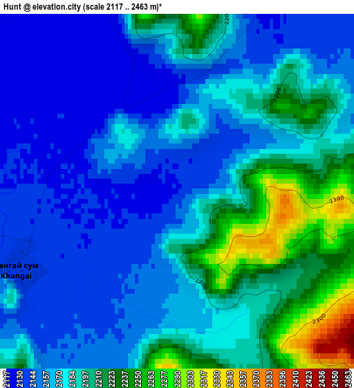
Below is the Elevation map of Hunt, which displays elevation range with different colors. Scale of the first map is from 2117 to 2463 m (6946 to 8081 ft) with average elevation of 2178.9 meters (=7149 ft) [note 1]
These maps also provides idea of topography and contour of this city, they are displayed at different zoom levels. More info about maps, scale and edge coordinates you can find below images.
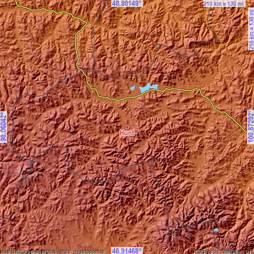
| \ | Map #1 | Topo.Map |
| Scale [m] | 2117..2463 m | × |
| Scale [ft] | 6946..8081 ft | × |
| Average | 2178.9 m = 7149 ft | × |
| Width | 6.56 km = 4.1 mi | 209.8 km = 130.4 mi |
| Height | 6.56 km = 4.1 mi | 209.8 km = 130.4 mi |
| ↑Max Latitude | 47.896143° | 48.80149° |
| Latitude at center | 47.86667° | 47.86667° |
| ↓Min Latitude | 47.837181° | 46.91468° |
| ← Min Longitude | 99.422725° | 98.06042° |
| Longitude center | 99.46667° | 99.46667° |
| →Max Longitude | 99.510615° | 100.87292° |
Nearby cities:
Cities around Hunt sort by population:
• Erdenet elevation 1690 m
120.4 km,  2°
2°
• Dzaanhoshuu 1765 m
113.5 km,  111°
111°
• Bayan-Uhaa 1648 m
107.1 km,  332°
332°
• Dzag 2013 m
105.2 km,  192°
192°
• Ider 1487 m
105.2 km,  16°
16°
• Höviyn Am 2409 m
97.5 km,  223°
223°
• Jargalant 2215 m
80.7 km,  171°
171°
• Orgil 1551 m
80.6 km,  353°
353°
• Teel 1935 m
80.2 km,  75°
75°
• Jargalant 2033 m
67.3 km,  123°
123°
• Tsahir 2189 m
51.5 km,  297°
297°
• Horgo 2052 m
44.6 km,  42°
42°
Multilingual:
 En español:
Hunt elevación 2130 m.
 En France:
Hunt élévation 2130 m.


Sources and notes:
- [note 1] Map square and city borders are not equal. Map elevation data is calculated only from area inside that square.
- [src 1] Elevation data from geonames database provided with same terms of usage.
- [src 2] The elevation map of Hunt is generated using elevation data from NASA's 3 arcsec (90m) resolution SRTM data.
- [src 3] Base (background) map © OpenStreetMap contributors tiles are generated by Geofabrik and OpenTopoMap.
Copyright & License:
This Hunt Elevation Map is licensed under CC BY-SA. You may reuse any part from this page, if you give a proper credit by linking to this URL:
 More info on terms of use page.