Mardzad elevation
Mardzad (Övörhangay), Mongolia elevation is 1889 meters and Mardzad elevation in feet is 6198 ft above sea level [src 1]. Mardzad is a seat of a second-order administrative division (feature code) with elevation that is 476 meters (1562 ft) bigger than average city elevation in Mongolia.
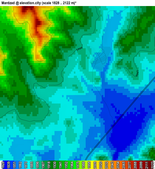
Below is the Elevation map of Mardzad, which displays elevation range with different colors. Scale of the first map is from 1828 to 2122 m (5997 to 6962 ft) with average elevation of 1899.1 meters (=6231 ft) [note 1]
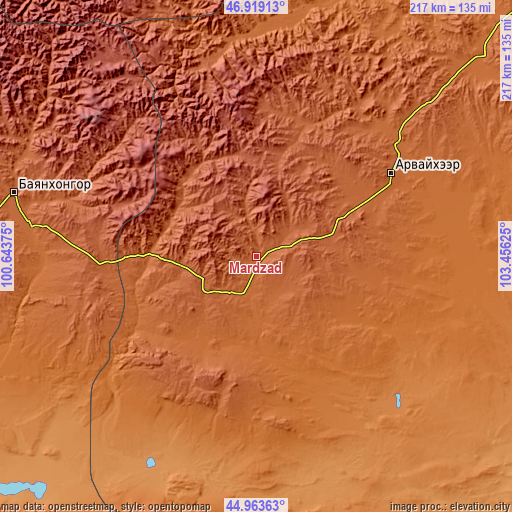
These maps also provides idea of topography and contour of this city, they are displayed at different zoom levels. More info about maps, scale and edge coordinates you can find below images.
| \ | Map #1 | Topo.Map |
| Scale [m] | 1828..2122 m | × |
| Scale [ft] | 5997..6962 ft | × |
| Average | 1899.1 m = 6231 ft | × |
| Width | 6.79 km = 4.2 mi | 217.4 km = 135.1 mi |
| Height | 6.79 km = 4.2 mi | 217.4 km = 135.1 mi |
| ↑Max Latitude | 45.980546° | 46.91913° |
| Latitude at center | 45.95° | 45.95° |
| ↓Min Latitude | 45.919437° | 44.96363° |
| ← Min Longitude | 102.006055° | 100.64375° |
| Longitude center | 102.05° | 102.05° |
| →Max Longitude | 102.093945° | 103.45625° |
Nearby cities:
Cities around Mardzad sort by population:
• Bayanhongor elevation 1873 m
106.3 km,  284°
284°
• Arvayheer 1838 m
65.9 km,  58°
58°
• Shiree 1482 m
105 km,  96°
96°
• Bayan Uula Sumu 1245 m
100.7 km,  210°
210°
• Övt 1681 m
97.6 km,  9°
9°
• Ulaan-Uul 1797 m
96.1 km, 277°
• Hoolt 1395 m
86 km,  122°
122°
• Bayan-Ulaan 1870 m
76.1 km,  33°
33°
• Arguut 1478 m
61.3 km,  152°
152°
• Ongi 1991 m
60.2 km,  17°
17°
• Hüremt 1963 m
49.6 km,  37°
37°
• Tsagaan-Ovoo 1816 m
45.7 km,  271°
271°
Multilingual:
 En español:
Mardzad elevación 1889 m.
 En France:
Mardzad élévation 1889 m.
 Auf Deutsch:
Mardzad höhe über dem Meeresspiegel ist 1889 m.

Sources and notes:
- [note 1] Map square and city borders are not equal. Map elevation data is calculated only from area inside that square.
- [src 1] Elevation data from geonames database provided with same terms of usage.
- [src 2] The elevation map of Mardzad is generated using elevation data from NASA's 3 arcsec (90m) resolution SRTM data.
- [src 3] Base (background) map © OpenStreetMap contributors tiles are generated by Geofabrik and OpenTopoMap.
Copyright & License:
This Mardzad Elevation Map is licensed under CC BY-SA. You may reuse any part from this page, if you give a proper credit by linking to this URL:
 More info on terms of use page.