Noyon Suma elevation
Noyon Suma (Ömnögovĭ), Mongolia elevation is 1887 meters and Noyon Suma elevation in feet is 6191 ft above sea level [src 1]. Noyon Suma is a seat of a second-order administrative division (feature code) with elevation that is 474 meters (1555 ft) bigger than average city elevation in Mongolia.
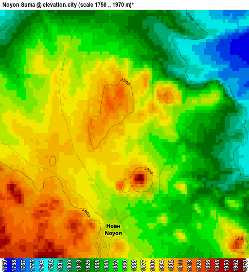
Below is the Elevation map of Noyon Suma, which displays elevation range with different colors. Scale of the first map is from 1750 to 1970 m (5741 to 6463 ft) with average elevation of 1860.5 meters (=6104 ft) [note 1]
These maps also provides idea of topography and contour of this city, they are displayed at different zoom levels. More info about maps, scale and edge coordinates you can find below images.
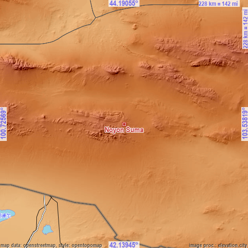
| \ | Map #1 | Topo.Map |
| Scale [m] | 1750..1970 m | × |
| Scale [ft] | 5741..6463 ft | × |
| Average | 1860.5 m = 6104 ft | × |
| Width | 7.13 km = 4.4 mi | 228.1 km = 141.7 mi |
| Height | 7.13 km = 4.4 mi | 228.1 km = 141.7 mi |
| ↑Max Latitude | 43.20565° | 44.19055° |
| Latitude at center | 43.17361° | 43.17361° |
| ↓Min Latitude | 43.141553° | 42.13945° |
| ← Min Longitude | 102.087995° | 100.72569° |
| Longitude center | 102.13194° | 102.13194° |
| →Max Longitude | 102.175885° | 103.53819° |
Nearby cities:
Cities around Noyon Suma sort by population:
• Hovd elevation 1525 m
166.4 km,  1°
1°
• Dalandzadgad 1470 m
190.5 km,  76°
76°
• Sharhulsan 1076 m
224.8 km,  43°
43°
• Örgön 1584 m
222.7 km,  321°
321°
• Ögöömör 1517 m
201.3 km,  70°
70°
• Hatansuudal 1345 m
185 km,  325°
325°
• Hovd 1446 m
167.2 km,  6°
6°
• Tsoohor 1822 m
158 km, 84°
• Bulgan 1296 m
153.1 km,  47°
47°
• Dalay 1563 m
116.4 km, 73°
• Urt 1727 m
88.1 km,  274°
274°
• Saynshand 2031 m
59 km,  33°
33°
Multilingual:
 En español:
Noyon Suma elevación 1887 m.
 En France:
Noyon Suma élévation 1887 m.
 Auf Deutsch:
Noyon Suma höhe über dem Meeresspiegel ist 1887 m.

Sources and notes:
- [note 1] Map square and city borders are not equal. Map elevation data is calculated only from area inside that square.
- [src 1] Elevation data from geonames database provided with same terms of usage.
- [src 2] The elevation map of Noyon Suma is generated using elevation data from NASA's 3 arcsec (90m) resolution SRTM data.
- [src 3] Base (background) map © OpenStreetMap contributors tiles are generated by Geofabrik and OpenTopoMap.
Copyright & License:
This Noyon Suma Elevation Map is licensed under CC BY-SA. You may reuse any part from this page, if you give a proper credit by linking to this URL:
 More info on terms of use page.