Loikaw elevation
Loikaw (Kayah, Loikaw District), Myanmar elevation is 893 meters and Loikaw elevation in feet is 2930 ft above sea level [src 1]. Loikaw is a seat of a first-order administrative division (feature code) with elevation that is 714 meters (2343 ft) bigger than average city elevation in Myanmar.
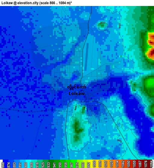
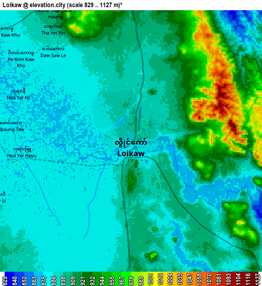
Below is the Elevation map of Loikaw, which displays elevation range with different colors. Scale of the first map is from 866 to 1084 m (2841 to 3556 ft) with average elevation of 890.8 meters (=2923 ft) [note 1]
These maps also provides idea of topography and contour of this city, they are displayed at different zoom levels. More info about maps, scale and edge coordinates you can find below images.
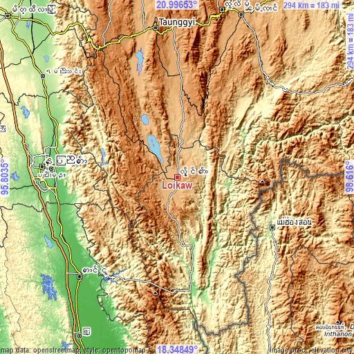
| \ | Map #1 | Map #2 | Topo.Map |
| Scale [m] | 866..1084 m | 829..1127 m | × |
| Scale [ft] | 2841..3556 ft | 2720..3698 ft | × |
| Average | 890.8 m = 2923 ft | 903.8 m = 2965 ft | × |
| Width | 9.2 km = 5.7 mi | 18.4 km = 11.4 mi | 294.4 km = 182.9 mi |
| Height | 9.2 km = 5.7 mi | 18.4 km = 11.4 mi | 294.5 km = 183 mi |
| ↑Max Latitude | 19.719354° | 19.760716° | 20.99653° |
| Latitude at center | 19.67798° | 19.67798° | 19.67798° |
| ↓Min Latitude | 19.636596° | 19.595201° | 18.34849° |
| ← Min Longitude | 97.165805° | 97.121859° | 95.8035° |
| Longitude center | 97.20975° | 97.20975° | 97.20975° |
| →Max Longitude | 97.253695° | 97.297641° | 98.616° |
Nearby cities:
Cities around Loikaw sort by population:
• Nay Pyi Taw elevation 122 m
113.3 km,  273°
273°
• Meiktila 244 m
194.1 km,  313°
313°
• Taunggyi 1396 m
124.9 km,  351°
351°
• Taungoo 56 m
115.3 km,  224°
224°
• Thayetmyo 47 m
216.1 km,  259°
259°
• Pyinmana 101 m
105.1 km, 273°
• Nyaunglebin 19 m
198.5 km,  194°
194°
• Taungdwingyi 143 m
177.9 km,  281°
281°
• Yamethin 203 m
139.8 km, 306°
• Myaydo 48 m
211.8 km, 260°
• Pyu 55 m
155.9 km,  211°
211°
• Nyaungshwe 894 m
113 km, 345°
Multilingual:
 En español:
Loikaw elevación 893 m.
 En France:
Loikaw élévation 893 m.


Sources and notes:
- [note 1] Map square and city borders are not equal. Map elevation data is calculated only from area inside that square.
- [src 1] Elevation data from geonames database provided with same terms of usage.
- [src 2] The elevation map of Loikaw is generated using elevation data from NASA's 3 arcsec (90m) resolution SRTM data.
- [src 3] Base (background) map © OpenStreetMap contributors tiles are generated by Geofabrik and OpenTopoMap.
Copyright & License:
This Loikaw Elevation Map is licensed under CC BY-SA. You may reuse any part from this page, if you give a proper credit by linking to this URL:
 More info on terms of use page.