Taunggyi elevation
Taunggyi (Shan, Taunggyi District), Myanmar elevation is 1396 meters and Taunggyi elevation in feet is 4580 ft above sea level [src 1]. Taunggyi is a seat of a first-order administrative division (feature code) with elevation that is 1217 meters (3993 ft) bigger than average city elevation in Myanmar.
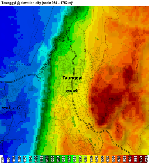
Below is the Elevation map of Taunggyi, which displays elevation range with different colors. Scale of the first map is from 954 to 1752 m (3130 to 5748 ft) with average elevation of 1335.9 meters (=4383 ft) [note 1]
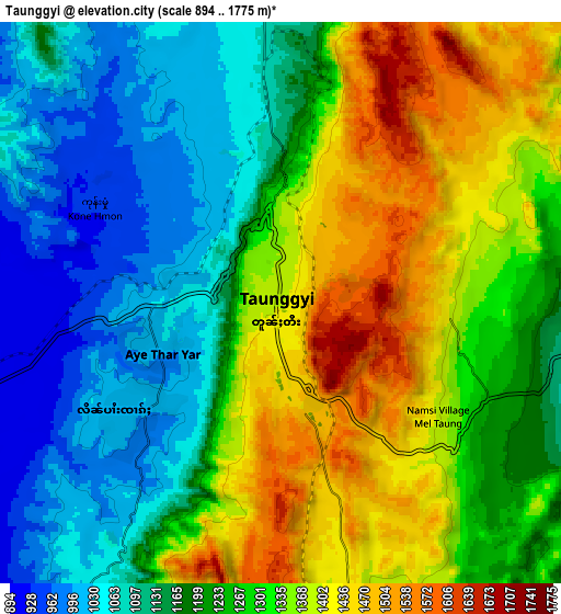
These maps also provides idea of topography and contour of this city, they are displayed at different zoom levels. More info about maps, scale and edge coordinates you can find below images.
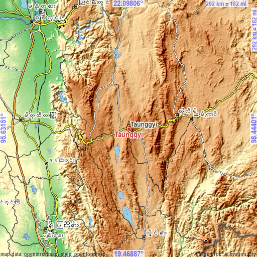
| \ | Map #1 | Map #2 | Topo.Map |
| Scale [m] | 954..1752 m | 894..1775 m | × |
| Scale [ft] | 3130..5748 ft | 2933..5823 ft | × |
| Average | 1335.9 m = 4383 ft | 1249.4 m = 4099 ft | × |
| Width | 9.14 km = 5.7 mi | 18.27 km = 11.4 mi | 292.3 km = 181.6 mi |
| Height | 9.14 km = 5.7 mi | 18.27 km = 11.4 mi | 292.4 km = 181.7 mi |
| ↑Max Latitude | 20.830269° | 20.871336° | 22.09806° |
| Latitude at center | 20.78919° | 20.78919° | 20.78919° |
| ↓Min Latitude | 20.7481° | 20.706999° | 19.46887° |
| ← Min Longitude | 96.993815° | 96.949869° | 95.63151° |
| Longitude center | 97.03776° | 97.03776° | 97.03776° |
| →Max Longitude | 97.081705° | 97.125651° | 98.44401° |
Nearby cities:
Cities around Taunggyi sort by population:
• Mandalay elevation 83 m
164.7 km,  323°
323°
• Nay Pyi Taw 122 m
149.8 km,  219°
219°
• Meiktila 244 m
122.9 km,  274°
274°
• Myingyan 76 m
186.6 km,  293°
293°
• Pyin Oo Lwin 1088 m
151 km,  336°
336°
• Pyinmana 101 m
145.5 km, 216°
• Sagaing 75 m
163.4 km, 317°
• Taungdwingyi 143 m
178.2 km,  240°
240°
• Yamethin 203 m
101.6 km,  246°
246°
• Kyaukse 86 m
130.4 km,  314°
314°
• Loikaw 893 m
124.9 km,  171°
171°
• Nyaungshwe 894 m
17.9 km, 217°
Multilingual:
 En español:
Taunggyi elevación 1396 m.
 En France:
Taunggyi élévation 1396 m.
 Auf Deutsch:
Taunggyi höhe über dem Meeresspiegel ist 1396 m.

Sources and notes:
- [note 1] Map square and city borders are not equal. Map elevation data is calculated only from area inside that square.
- [src 1] Elevation data from geonames database provided with same terms of usage.
- [src 2] The elevation map of Taunggyi is generated using elevation data from NASA's 3 arcsec (90m) resolution SRTM data.
- [src 3] Base (background) map © OpenStreetMap contributors tiles are generated by Geofabrik and OpenTopoMap.
Copyright & License:
This Taunggyi Elevation Map is licensed under CC BY-SA. You may reuse any part from this page, if you give a proper credit by linking to this URL:
 More info on terms of use page.