Myingyan elevation
Myingyan (Mandalay, Myingyan District), Myanmar elevation is 76 meters and Myingyan elevation in feet is 249 ft above sea level [src 1]. Myingyan is a populated place (feature code) with elevation that is 103 meters (338 ft) smaller than average city elevation in Myanmar.
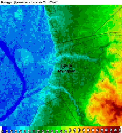
Below is the Elevation map of Myingyan, which displays elevation range with different colors. Scale of the first map is from 53 to 139 m (174 to 456 ft) with average elevation of 78.1 meters (=256 ft) [note 1]
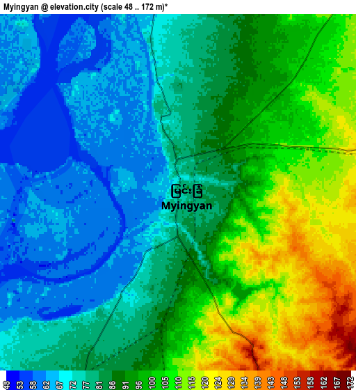
These maps also provides idea of topography and contour of this city, they are displayed at different zoom levels. More info about maps, scale and edge coordinates you can find below images.
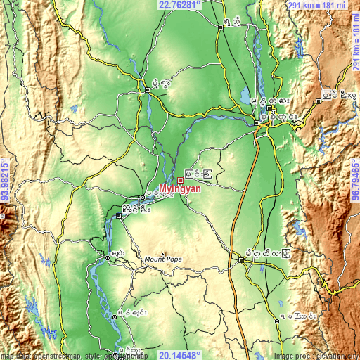
| \ | Map #1 | Map #2 | Topo.Map |
| Scale [m] | 53..139 m | 48..172 m | × |
| Scale [ft] | 174..456 ft | 157..564 ft | × |
| Average | 78.1 m = 256 ft | 86.9 m = 285 ft | × |
| Width | 9.09 km = 5.6 mi | 18.19 km = 11.3 mi | 291 km = 180.8 mi |
| Height | 9.09 km = 5.6 mi | 18.19 km = 11.3 mi | 291 km = 180.8 mi |
| ↑Max Latitude | 21.500913° | 21.541794° | 22.76281° |
| Latitude at center | 21.46002° | 21.46002° | 21.46002° |
| ↓Min Latitude | 21.419116° | 21.3782° | 20.14548° |
| ← Min Longitude | 95.344455° | 95.300509° | 93.98215° |
| Longitude center | 95.3884° | 95.3884° | 95.3884° |
| →Max Longitude | 95.432345° | 95.476291° | 96.79465° |
Nearby cities:
Cities around Myingyan sort by population:
• Mandalay elevation 83 m
91.8 km,  51°
51°
• Monywa 81 m
76.7 km,  340°
340°
• Meiktila 244 m
81 km,  143°
143°
• Pakokku 70 m
34.4 km,  246°
246°
• Pyin Oo Lwin 1088 m
127.5 km,  59°
59°
• Yenangyaung 56 m
123 km,  205°
205°
• Chauk 59 m
86 km,  223°
223°
• Shwebo 111 m
127.4 km,  14°
14°
• Sagaing 75 m
76.8 km, 52°
• Yamethin 203 m
138.3 km,  145°
145°
• Minbu 49 m
151.9 km,  200°
200°
• Kyaukse 86 m
78.9 km,  78°
78°
Multilingual:
 En español:
Myingyan elevación 76 m.
 En France:
Myingyan élévation 76 m.


Sources and notes:
- [note 1] Map square and city borders are not equal. Map elevation data is calculated only from area inside that square.
- [src 1] Elevation data from geonames database provided with same terms of usage.
- [src 2] The elevation map of Myingyan is generated using elevation data from NASA's 3 arcsec (90m) resolution SRTM data.
- [src 3] Base (background) map © OpenStreetMap contributors tiles are generated by Geofabrik and OpenTopoMap.
Copyright & License:
This Myingyan Elevation Map is licensed under CC BY-SA. You may reuse any part from this page, if you give a proper credit by linking to this URL:
 More info on terms of use page.