Maintirano elevation
Maintirano (Melaky), Madagascar elevation is 11 meters and Maintirano elevation in feet is 36 ft above sea level [src 1]. Maintirano is a seat of a first-order administrative division (feature code) with elevation that is 546 meters (1791 ft) smaller than average city elevation in Madagascar.
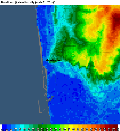
Below is the Elevation map of Maintirano, which displays elevation range with different colors. Scale of the first map is from 2 to 76 m (7 to 249 ft) with average elevation of 22.7 meters (=74 ft) [note 1]
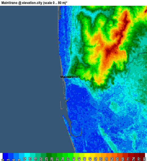
These maps also provides idea of topography and contour of this city, they are displayed at different zoom levels. More info about maps, scale and edge coordinates you can find below images.
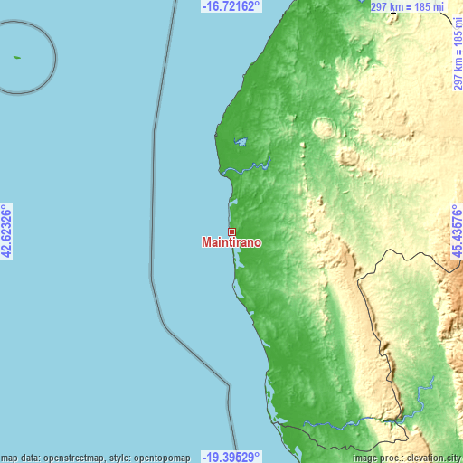
| \ | Map #1 | Map #2 | Topo.Map |
| Scale [m] | 2..76 m | 0..80 m | × |
| Scale [ft] | 7..249 ft | 0..262 ft | × |
| Average | 22.7 m = 74 ft | 21.8 m = 72 ft | × |
| Width | 9.29 km = 5.8 mi | 18.58 km = 11.5 mi | 297.3 km = 184.7 mi |
| Height | 9.29 km = 5.8 mi | 18.58 km = 11.5 mi | 297.3 km = 184.7 mi |
| ↑Max Latitude | -18.021756° | -17.979961° | -16.72162° |
| Latitude at center | -18.06354° | -18.06354° | -18.06354° |
| ↓Min Latitude | -18.105314° | -18.147079° | -19.39529° |
| ← Min Longitude | 43.985565° | 43.941619° | 42.62326° |
| Longitude center | 44.02951° | 44.02951° | 44.02951° |
| →Max Longitude | 44.073455° | 44.117401° | 45.43576° |
Nearby cities:
Cities around Maintirano sort by population:
• Soavinandriana elevation 1500 m
310.2 km,  113°
113°
• Morondava 8 m
249.3 km,  173°
173°
• Tsiroanomandidy 862 m
226.8 km, 110°
• Miandrarivo 1424 m
324.4 km,  118°
118°
• Maevatanana 64 m
322.1 km,  67°
67°
• Belo sur Tsiribihina 22 m
189.7 km,  163°
163°
• Sitampiky 100 m
269.1 km,  54°
54°
• Miandrivazo 67 m
221.5 km,  137°
137°
• Fenoarivo Be 983 m
271.1 km,  98°
98°
• Ankazobe 1231 m
327.3 km,  94°
94°
• Mahabe 293 m
176 km, 51°
• Miarinarivo 1325 m
319.1 km, 108°
Multilingual:
 En español:
Maintirano elevación 11 m.
 En France:
Maintirano élévation 11 m.
 Auf Deutsch:
Maintirano höhe über dem Meeresspiegel ist 11 m.

Sources and notes:
- [note 1] Map square and city borders are not equal. Map elevation data is calculated only from area inside that square.
- [src 1] Elevation data from geonames database provided with same terms of usage.
- [src 2] The elevation map of Maintirano is generated using elevation data from NASA's 3 arcsec (90m) resolution SRTM data.
- [src 3] Base (background) map © OpenStreetMap contributors tiles are generated by Geofabrik and OpenTopoMap.
Copyright & License:
This Maintirano Elevation Map is licensed under CC BY-SA. You may reuse any part from this page, if you give a proper credit by linking to this URL:
 More info on terms of use page.