Bouarfa elevation
Bouarfa (Oriental, Figuig), Morocco elevation is 1169 meters and Bouarfa elevation in feet is 3835 ft above sea level [src 1]. Bouarfa is a seat of a third-order administrative division (feature code) with elevation that is 553 meters (1814 ft) bigger than average city elevation in Morocco.
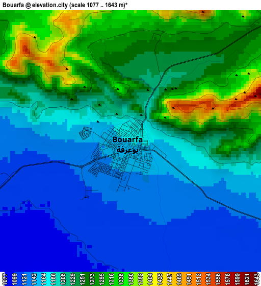
Below is the Elevation map of Bouarfa, which displays elevation range with different colors. Scale of the first map is from 1077 to 1643 m (3533 to 5390 ft) with average elevation of 1209 meters (=3967 ft) [note 1]
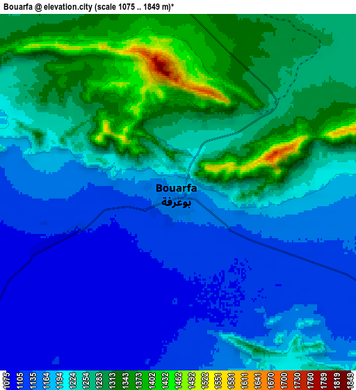
These maps also provides idea of topography and contour of this city, they are displayed at different zoom levels. More info about maps, scale and edge coordinates you can find below images.
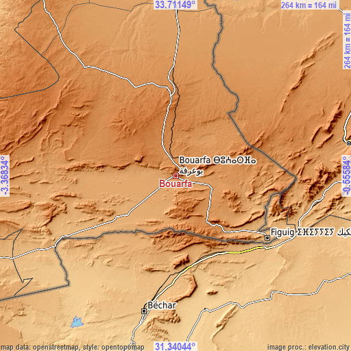
| \ | Map #1 | Map #2 | Topo.Map |
| Scale [m] | 1077..1643 m | 1075..1849 m | × |
| Scale [ft] | 3533..5390 ft | 3527..6066 ft | × |
| Average | 1209 m = 3967 ft | 1219.3 m = 4000 ft | × |
| Width | 8.24 km = 5.1 mi | 16.48 km = 10.2 mi | 263.6 km = 163.8 mi |
| Height | 8.24 km = 5.1 mi | 16.48 km = 10.2 mi | 263.6 km = 163.8 mi |
| ↑Max Latitude | 32.570832° | 32.607858° | 33.71149° |
| Latitude at center | 32.53379° | 32.53379° | 32.53379° |
| ↓Min Latitude | 32.496733° | 32.459661° | 31.34044° |
| ← Min Longitude | -2.006035° | -2.049981° | -3.36834° |
| Longitude center | -1.96209° | -1.96209° | -1.96209° |
| →Max Longitude | -1.918145° | -1.874199° | -0.55584° |
Nearby cities:
Cities around Bouarfa sort by population:
• Taourirt elevation 394 m
225.7 km,  337°
337°
• Guercif 367 m
228.2 km,  325°
325°
• Jerada 1045 m
198.3 km,  354°
354°
• El Aïoun 604 m
233.4 km, 347°
• Aïn Beni Mathar 917 m
164.2 km,  357°
357°
• Figuig (Centre) 898 m
83.6 km,  124°
124°
• Aoufous 1031 m
228.6 km,  245°
245°
• Almis Marmoucha 1692 m
224.7 km,  292°
292°
• Guenfouda 818 m
216.9 km, 357°
• Tiouli 1101 m
204.1 km,  3°
3°
• Missour 883 m
198 km, 286°
• Debdou 994 m
189.8 km, 328°
Multilingual:
 En español:
Bouarfa elevación 1169 m.
 En France:
Bouafra, Bou Arfa élévation 1169 m.
 Auf Deutsch:
Bouarfa höhe über dem Meeresspiegel ist 1169 m.

Sources and notes:
- [note 1] Map square and city borders are not equal. Map elevation data is calculated only from area inside that square.
- [src 1] Elevation data from geonames database provided with same terms of usage.
- [src 2] The elevation map of Bouarfa is generated using elevation data from NASA's 3 arcsec (90m) resolution SRTM data.
- [src 3] Base (background) map © OpenStreetMap contributors tiles are generated by Geofabrik and OpenTopoMap.
Copyright & License:
This Bouarfa Elevation Map is licensed under CC BY-SA. You may reuse any part from this page, if you give a proper credit by linking to this URL:
 More info on terms of use page.