Guercif elevation
Guercif (Fès-Meknès, Taza), Morocco elevation is 367 meters and Guercif elevation in feet is 1204 ft above sea level [src 1]. Guercif is a seat of a third-order administrative division (feature code) with elevation that is 249 meters (817 ft) smaller than average city elevation in Morocco.
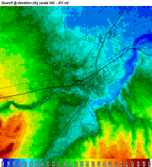
Below is the Elevation map of Guercif, which displays elevation range with different colors. Scale of the first map is from 343 to 431 m (1125 to 1414 ft) with average elevation of 373.3 meters (=1225 ft) [note 1]
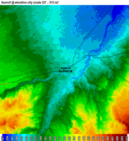
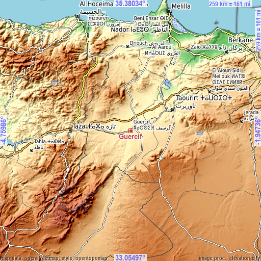
These maps also provides idea of topography and contour of this city, they are displayed at different zoom levels. More info about maps, scale and edge coordinates you can find below images.
| \ | Map #1 | Map #2 | Topo.Map |
| Scale [m] | 343..431 m | 327..512 m | × |
| Scale [ft] | 1125..1414 ft | 1073..1680 ft | × |
| Average | 373.3 m = 1225 ft | 388.5 m = 1275 ft | × |
| Width | 8.08 km = 5 mi | 16.16 km = 10 mi | 258.6 km = 160.7 mi |
| Height | 8.08 km = 5 mi | 16.16 km = 10 mi | 258.6 km = 160.7 mi |
| ↑Max Latitude | 34.262007° | 34.298319° | 35.38034° |
| Latitude at center | 34.22568° | 34.22568° | 34.22568° |
| ↓Min Latitude | 34.189337° | 34.152978° | 33.05497° |
| ← Min Longitude | -3.397555° | -3.441501° | -4.75986° |
| Longitude center | -3.35361° | -3.35361° | -3.35361° |
| →Max Longitude | -3.309665° | -3.265719° | -1.94736° |
Nearby cities:
Cities around Guercif sort by population:
• Taza elevation 530 m
60.4 km,  268°
268°
• Taourirt 394 m
46.5 km,  64°
64°
• El Aïoun 604 m
87.3 km, 62°
• Midar 388 m
81.1 km,  348°
348°
• Tmourghout 899 m
71.5 km,  240°
240°
• Tazarine 1370 m
85.6 km, 243°
• Oued Amlil 301 m
85.2 km, 268°
• Tiztoutine 198 m
85 km,  12°
12°
• Hassi Berkane 393 m
81.5 km,  33°
33°
• Ajdir 1060 m
81 km,  315°
315°
• Aknoul 1021 m
67 km, 315°
• Debdou 994 m
39.4 km,  133°
133°
Multilingual:
 En español:
Guercif elevación 367 m.
 En France:
Guercif élévation 367 m.


Sources and notes:
- [note 1] Map square and city borders are not equal. Map elevation data is calculated only from area inside that square.
- [src 1] Elevation data from geonames database provided with same terms of usage.
- [src 2] The elevation map of Guercif is generated using elevation data from NASA's 3 arcsec (90m) resolution SRTM data.
- [src 3] Base (background) map © OpenStreetMap contributors tiles are generated by Geofabrik and OpenTopoMap.
Copyright & License:
This Guercif Elevation Map is licensed under CC BY-SA. You may reuse any part from this page, if you give a proper credit by linking to this URL:
 More info on terms of use page.