Taourirt elevation
Taourirt (Oriental), Morocco elevation is 394 meters and Taourirt elevation in feet is 1293 ft above sea level [src 1]. Taourirt is a seat of a third-order administrative division (feature code) with elevation that is 222 meters (728 ft) smaller than average city elevation in Morocco.
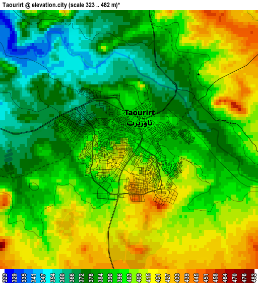
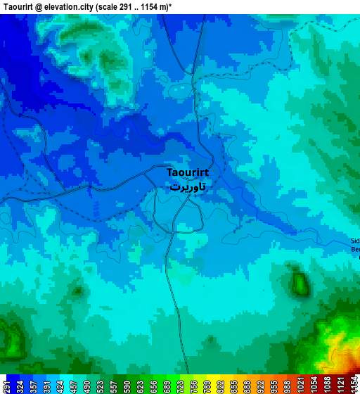
Below is the Elevation map of Taourirt, which displays elevation range with different colors. Scale of the first map is from 323 to 482 m (1060 to 1581 ft) with average elevation of 395.4 meters (=1297 ft) [note 1]
These maps also provides idea of topography and contour of this city, they are displayed at different zoom levels. More info about maps, scale and edge coordinates you can find below images.
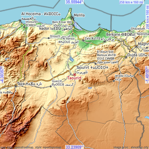
| \ | Map #1 | Map #2 | Topo.Map |
| Scale [m] | 323..482 m | 291..1154 m | × |
| Scale [ft] | 1060..1581 ft | 955..3786 ft | × |
| Average | 395.4 m = 1297 ft | 434.3 m = 1425 ft | × |
| Width | 8.06 km = 5 mi | 16.13 km = 10 mi | 258 km = 160.3 mi |
| Height | 8.06 km = 5 mi | 16.13 km = 10 mi | 258 km = 160.3 mi |
| ↑Max Latitude | 34.443559° | 34.479792° | 35.55944° |
| Latitude at center | 34.40731° | 34.40731° | 34.40731° |
| ↓Min Latitude | 34.371045° | 34.334765° | 33.23909° |
| ← Min Longitude | -2.941265° | -2.985211° | -4.30357° |
| Longitude center | -2.89732° | -2.89732° | -2.89732° |
| →Max Longitude | -2.853375° | -2.809429° | -1.49107° |
Nearby cities:
Cities around Taourirt sort by population:
• Berkane elevation 173 m
77.7 km,  42°
42°
• Guercif 367 m
46.5 km,  244°
244°
• Jerada 1045 m
68.5 km,  99°
99°
• Al Aaroui 177 m
67.9 km,  351°
351°
• El Aïoun 604 m
40.8 km,  61°
61°
• Zaïo 198 m
61.4 km,  14°
14°
• Mosquée 799 m
62.7 km, 44°
• Selouane 80 m
74.1 km,  356°
356°
• Tiztoutine 198 m
66.9 km,  339°
339°
• Rislane 1020 m
56.8 km, 44°
• Debdou 994 m
49.1 km,  195°
195°
• Hassi Berkane 393 m
48.1 km,  3°
3°
Multilingual:
 En español:
Taourirt elevación 394 m.
 En France:
Taourirt élévation 394 m.
 Auf Deutsch:
Taourirt höhe über dem Meeresspiegel ist 394 m.

Sources and notes:
- [note 1] Map square and city borders are not equal. Map elevation data is calculated only from area inside that square.
- [src 1] Elevation data from geonames database provided with same terms of usage.
- [src 2] The elevation map of Taourirt is generated using elevation data from NASA's 3 arcsec (90m) resolution SRTM data.
- [src 3] Base (background) map © OpenStreetMap contributors tiles are generated by Geofabrik and OpenTopoMap.
Copyright & License:
This Taourirt Elevation Map is licensed under CC BY-SA. You may reuse any part from this page, if you give a proper credit by linking to this URL:
 More info on terms of use page.