Anyksciai elevation
Anyksciai (Utena, Anykščiai), Lithuania elevation is 74 meters and Anyksciai elevation in feet is 243 ft above sea level [src 1]. Anyksciai is a populated place (feature code) with elevation that is 19 meters (62 ft) smaller than average city elevation in Lithuania.
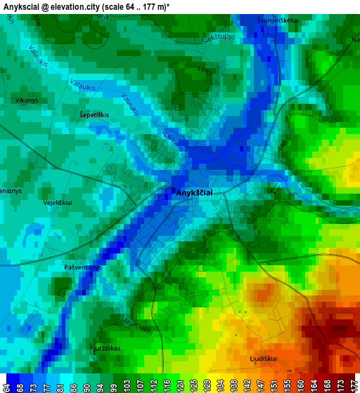
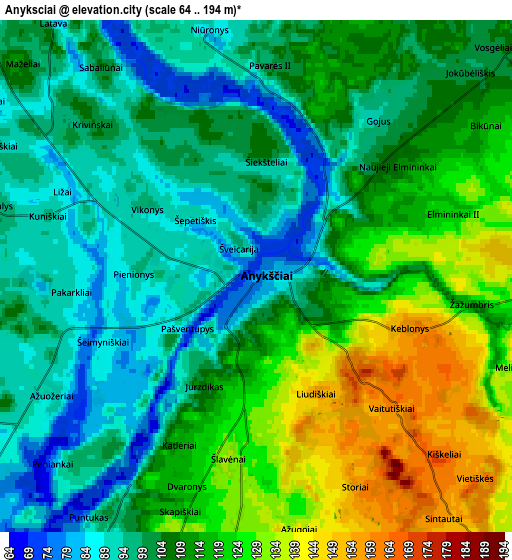
Below is the Elevation map of Anyksciai, which displays elevation range with different colors. Scale of the first map is from 64 to 177 m (210 to 581 ft) with average elevation of 99.9 meters (=328 ft) [note 1]
These maps also provides idea of topography and contour of this city, they are displayed at different zoom levels. More info about maps, scale and edge coordinates you can find below images.
| \ | Map #1 | Map #2 | Topo.Map |
| Scale [m] | 64..177 m | 64..194 m | × |
| Scale [ft] | 210..581 ft | 210..636 ft | × |
| Average | 99.9 m = 328 ft | 108.4 m = 356 ft | × |
| Width | 5.53 km = 3.4 mi | 11.06 km = 6.9 mi | 177 km = 110 mi |
| Height | 5.53 km = 3.4 mi | 11.06 km = 6.9 mi | 177 km = 110 mi |
| ↑Max Latitude | 55.550437° | 55.575288° | 56.31354° |
| Latitude at center | 55.52557° | 55.52557° | 55.52557° |
| ↓Min Latitude | 55.500687° | 55.475789° | 54.7215° |
| ← Min Longitude | 25.058695° | 25.014749° | 23.69639° |
| Longitude center | 25.10264° | 25.10264° | 25.10264° |
| →Max Longitude | 25.146585° | 25.190531° | 26.50889° |
Nearby cities:
Cities around Anyksciai sort by population:
• Panevėžys elevation 52 m
52.6 km,  296°
296°
• Utena 104 m
31.4 km,  95°
95°
• Ukmerge 72 m
37.9 km,  216°
216°
• Rokiškis 137 m
57.2 km,  32°
32°
• Kupiskis 97 m
35.8 km,  347°
347°
• Širvintos 115 m
54.4 km,  189°
189°
• Molėtai 164 m
38.9 km,  149°
149°
• Švenčionėliai 160 m
69.8 km,  125°
125°
• Ignalina 166 m
69.8 km,  107°
107°
• Ramygala 57 m
50.5 km,  268°
268°
• Obeliai 91 m
49.4 km,  3°
3°
• Vabalninkas 64 m
55.3 km,  336°
336°
Multilingual:
 En español:
Anyksciai elevación 74 m.
 En France:
Anykščiai élévation 74 m.
 Auf Deutsch:
Anykščiai höhe über dem Meeresspiegel ist 74 m.

Sources and notes:
- [note 1] Map square and city borders are not equal. Map elevation data is calculated only from area inside that square.
- [src 1] Elevation data from geonames database provided with same terms of usage.
- [src 2] The elevation map of Anyksciai is generated using elevation data from NASA's 3 arcsec (90m) resolution SRTM data.
- [src 3] Base (background) map © OpenStreetMap contributors tiles are generated by Geofabrik and OpenTopoMap.
Copyright & License:
This Anyksciai Elevation Map is licensed under CC BY-SA. You may reuse any part from this page, if you give a proper credit by linking to this URL:
 More info on terms of use page.