Panevėžys elevation
Panevėžys, Lithuania elevation is 52 meters and Panevėžys elevation in feet is 171 ft above sea level [src 1]. Panevėžys is a seat of a first-order administrative division (feature code) with elevation that is 41 meters (135 ft) smaller than average city elevation in Lithuania.
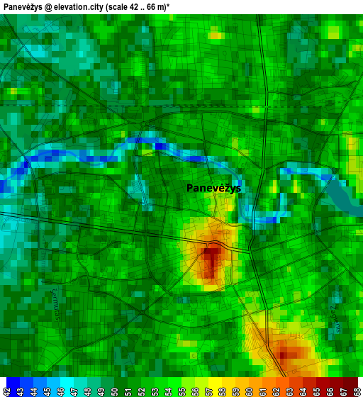
Below is the Elevation map of Panevėžys, which displays elevation range with different colors. Scale of the first map is from 42 to 66 m (138 to 217 ft) with average elevation of 51.3 meters (=168 ft) [note 1]
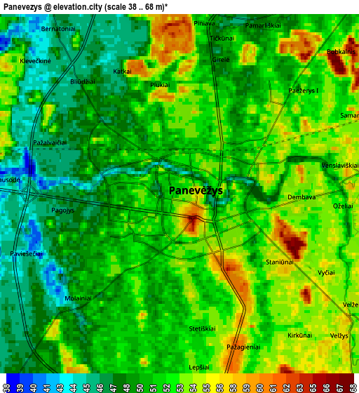
These maps also provides idea of topography and contour of this city, they are displayed at different zoom levels. More info about maps, scale and edge coordinates you can find below images.
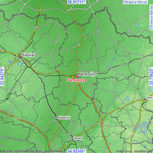
| \ | Map #1 | Map #2 | Topo.Map |
| Scale [m] | 42..66 m | 38..68 m | × |
| Scale [ft] | 138..217 ft | 125..223 ft | × |
| Average | 51.3 m = 168 ft | 51 m = 167 ft | × |
| Width | 5.5 km = 3.4 mi | 11 km = 6.8 mi | 176.1 km = 109.4 mi |
| Height | 5.5 km = 3.4 mi | 11 km = 6.8 mi | 176.1 km = 109.4 mi |
| ↑Max Latitude | 55.758065° | 55.782785° | 56.51711° |
| Latitude at center | 55.73333° | 55.73333° | 55.73333° |
| ↓Min Latitude | 55.708579° | 55.683812° | 54.93349° |
| ← Min Longitude | 24.306055° | 24.262109° | 22.94375° |
| Longitude center | 24.35° | 24.35° | 24.35° |
| →Max Longitude | 24.393945° | 24.437891° | 25.75625° |
Nearby cities:
Cities around Panevėžys sort by population:
• Kėdainiai elevation 39 m
54.9 km,  205°
205°
• Radviliskis 124 m
51.9 km,  280°
280°
• Birzai 53 m
57.6 km,  25°
25°
• Anyksciai 74 m
52.6 km,  116°
116°
• Pasvalys 35 m
36.4 km,  5°
5°
• Kupiskis 97 m
41.1 km,  73°
73°
• Pakruojis 61 m
41.2 km,  311°
311°
• Šeduva 96 m
37.2 km,  272°
272°
• Linkuva 76 m
45.8 km,  328°
328°
• Ramygala 57 m
24.6 km,  187°
187°
• Obeliai 91 m
56.7 km,  62°
62°
• Vabalninkas 64 m
37.1 km,  42°
42°
Multilingual:
 En español:
Panevėžys elevación 52 m.
 En France:
Panevėžys élévation 52 m.
 Auf Deutsch:
Ponewiesch höhe über dem Meeresspiegel ist 52 m.

Sources and notes:
- [note 1] Map square and city borders are not equal. Map elevation data is calculated only from area inside that square.
- [src 1] Elevation data from geonames database provided with same terms of usage.
- [src 2] The elevation map of Panevėžys is generated using elevation data from NASA's 3 arcsec (90m) resolution SRTM data.
- [src 3] Base (background) map © OpenStreetMap contributors tiles are generated by Geofabrik and OpenTopoMap.
Copyright & License:
This Panevėžys Elevation Map is licensed under CC BY-SA. You may reuse any part from this page, if you give a proper credit by linking to this URL:
 More info on terms of use page.