Telsiai elevation
Telsiai, Lithuania elevation is 135 meters and Telsiai elevation in feet is 443 ft above sea level [src 1]. Telsiai is a seat of a first-order administrative division (feature code) with elevation that is 42 meters (138 ft) bigger than average city elevation in Lithuania.
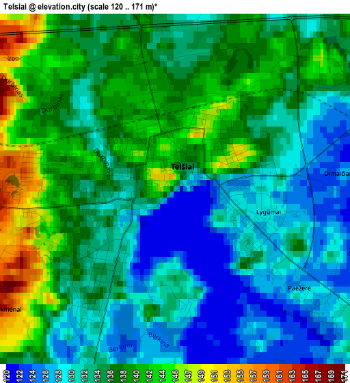
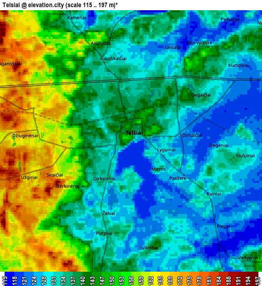
Below is the Elevation map of Telsiai, which displays elevation range with different colors. Scale of the first map is from 120 to 171 m (394 to 561 ft) with average elevation of 134.4 meters (=441 ft) [note 1]
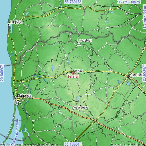
These maps also provides idea of topography and contour of this city, they are displayed at different zoom levels. More info about maps, scale and edge coordinates you can find below images.
| \ | Map #1 | Map #2 | Topo.Map |
| Scale [m] | 120..171 m | 115..197 m | × |
| Scale [ft] | 394..561 ft | 377..646 ft | × |
| Average | 134.4 m = 441 ft | 140.6 m = 461 ft | × |
| Width | 5.47 km = 3.4 mi | 10.93 km = 6.8 mi | 175 km = 108.7 mi |
| Height | 5.47 km = 3.4 mi | 10.93 km = 6.8 mi | 174.9 km = 108.7 mi |
| ↑Max Latitude | 56.005968° | 56.03053° | 56.76016° |
| Latitude at center | 55.98139° | 55.98139° | 55.98139° |
| ↓Min Latitude | 55.956796° | 55.932187° | 55.18661° |
| ← Min Longitude | 22.203275° | 22.159329° | 20.84097° |
| Longitude center | 22.24722° | 22.24722° | 22.24722° |
| →Max Longitude | 22.291165° | 22.335111° | 23.65347° |
Nearby cities:
Cities around Telsiai sort by population:
• Mazeikiai elevation 70 m
37.7 km,  8°
8°
• Plunge 106 m
26.3 km,  252°
252°
• Kuršėnai 104 m
42.9 km,  86°
86°
• Šilalė 98 m
54.8 km,  183°
183°
• Rietavas 112 m
34.8 km,  215°
215°
• Venta 72 m
36.3 km,  49°
49°
• Akmenė 73 m
43.2 km, 46°
• Viekšniai 65 m
32.9 km,  30°
30°
• Salantai 59 m
43 km,  281°
281°
• Varniai 160 m
27.5 km,  163°
163°
• Seda 115 m
23 km,  334°
334°
• Plateliai 161 m
27.8 km,  285°
285°
Multilingual:
 En español:
Telšiai elevación 135 m.
 En France:
Telšiai élévation 135 m.
 Auf Deutsch:
Telšiai, Telschen höhe über dem Meeresspiegel ist 135 m.

Sources and notes:
- [note 1] Map square and city borders are not equal. Map elevation data is calculated only from area inside that square.
- [src 1] Elevation data from geonames database provided with same terms of usage.
- [src 2] The elevation map of Telsiai is generated using elevation data from NASA's 3 arcsec (90m) resolution SRTM data.
- [src 3] Base (background) map © OpenStreetMap contributors tiles are generated by Geofabrik and OpenTopoMap.
Copyright & License:
This Telsiai Elevation Map is licensed under CC BY-SA. You may reuse any part from this page, if you give a proper credit by linking to this URL:
 More info on terms of use page.