Šilalė elevation
Šilalė (Tauragė County), Lithuania elevation is 98 meters and Šilalė elevation in feet is 322 ft above sea level [src 1]. Šilalė is a seat of a second-order administrative division (feature code) with elevation that is 5 meters (16 ft) bigger than average city elevation in Lithuania.
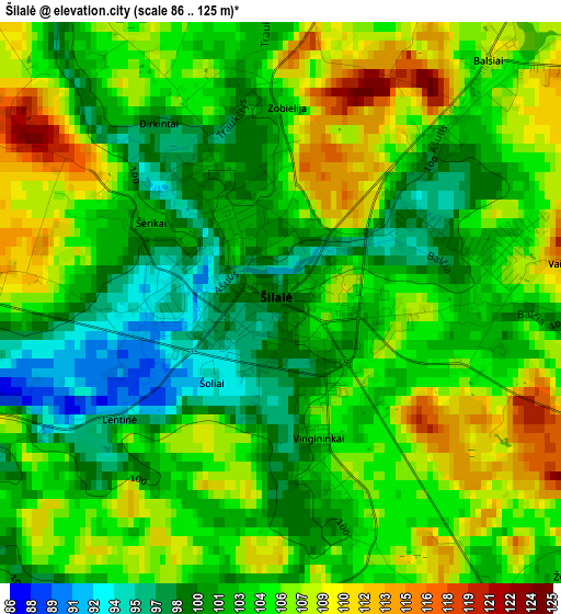
Below is the Elevation map of Šilalė, which displays elevation range with different colors. Scale of the first map is from 86 to 125 m (282 to 410 ft) with average elevation of 103.5 meters (=340 ft) [note 1]
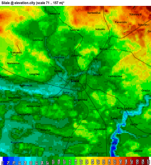
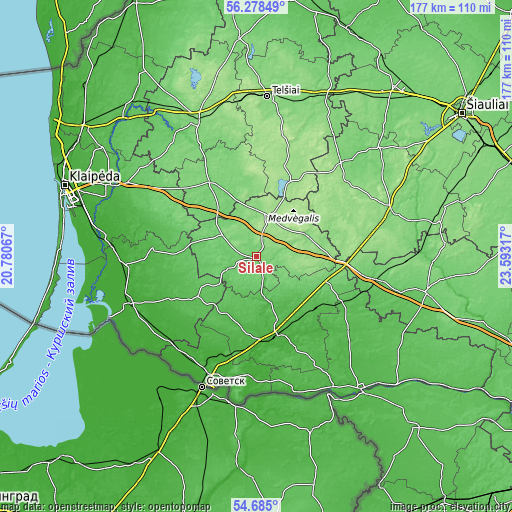
These maps also provides idea of topography and contour of this city, they are displayed at different zoom levels. More info about maps, scale and edge coordinates you can find below images.
| \ | Map #1 | Map #2 | Topo.Map |
| Scale [m] | 86..125 m | 71..157 m | × |
| Scale [ft] | 282..410 ft | 233..515 ft | × |
| Average | 103.5 m = 340 ft | 108.3 m = 355 ft | × |
| Width | 5.54 km = 3.4 mi | 11.07 km = 6.9 mi | 177.2 km = 110.1 mi |
| Height | 5.54 km = 3.4 mi | 11.07 km = 6.9 mi | 177.2 km = 110.1 mi |
| ↑Max Latitude | 55.514689° | 55.539563° | 56.27849° |
| Latitude at center | 55.4898° | 55.4898° | 55.4898° |
| ↓Min Latitude | 55.464895° | 55.439974° | 54.685° |
| ← Min Longitude | 22.142975° | 22.099029° | 20.78067° |
| Longitude center | 22.18692° | 22.18692° | 22.18692° |
| →Max Longitude | 22.230865° | 22.274811° | 23.59317° |
Nearby cities:
Cities around Šilalė sort by population:
• Telsiai elevation 135 m
54.8 km,  3°
3°
• Taurage 36 m
27.2 km,  166°
166°
• Plunge 106 m
51.6 km,  335°
335°
• Silute 8 m
47.1 km,  250°
250°
• Gargždai 27 m
55.5 km,  296°
296°
• Kelmė 131 m
49.6 km,  71°
71°
• Rietavas 112 m
31.1 km,  327°
327°
• Pagėgiai 18 m
42.8 km,  203°
203°
• Būgai 106 m
27.9 km,  107°
107°
• Priekulė 13 m
55.1 km,  277°
277°
• Žemaičių Naumiestis 23 m
33.8 km,  244°
244°
• Varniai 160 m
30.6 km,  22°
22°
Multilingual:
 En español:
Šilalė elevación 98 m.
 En France:
Šilalė élévation 98 m.


Sources and notes:
- [note 1] Map square and city borders are not equal. Map elevation data is calculated only from area inside that square.
- [src 1] Elevation data from geonames database provided with same terms of usage.
- [src 2] The elevation map of Šilalė is generated using elevation data from NASA's 3 arcsec (90m) resolution SRTM data.
- [src 3] Base (background) map © OpenStreetMap contributors tiles are generated by Geofabrik and OpenTopoMap.
Copyright & License:
This Šilalė Elevation Map is licensed under CC BY-SA. You may reuse any part from this page, if you give a proper credit by linking to this URL:
 More info on terms of use page.