Rietavas elevation
Rietavas (Telsiai), Lithuania elevation is 112 meters and Rietavas elevation in feet is 367 ft above sea level [src 1]. Rietavas is a seat of a second-order administrative division (feature code) with elevation that is 19 meters (62 ft) bigger than average city elevation in Lithuania.
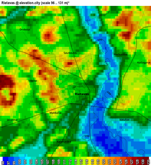
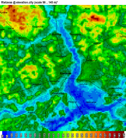
Below is the Elevation map of Rietavas, which displays elevation range with different colors. Scale of the first map is from 96 to 131 m (315 to 430 ft) with average elevation of 110.8 meters (=364 ft) [note 1]
These maps also provides idea of topography and contour of this city, they are displayed at different zoom levels. More info about maps, scale and edge coordinates you can find below images.
| \ | Map #1 | Map #2 | Topo.Map |
| Scale [m] | 96..131 m | 96..145 m | × |
| Scale [ft] | 315..430 ft | 315..476 ft | × |
| Average | 110.8 m = 364 ft | 112.9 m = 370 ft | × |
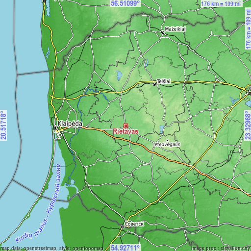
| Width | 5.5 km = 3.4 mi | 11.01 km = 6.8 mi | 176.1 km = 109.4 mi |
| Height | 5.5 km = 3.4 mi | 11.01 km = 6.8 mi | 176.1 km = 109.4 mi |
| ↑Max Latitude | 55.751819° | 55.776543° | 56.51099° |
| Latitude at center | 55.72708° | 55.72708° | 55.72708° |
| ↓Min Latitude | 55.702325° | 55.677554° | 54.92711° |
| ← Min Longitude | 21.879485° | 21.835539° | 20.51718° |
| Longitude center | 21.92343° | 21.92343° | 21.92343° |
| →Max Longitude | 21.967375° | 22.011321° | 23.32968° |
Nearby cities:
Cities around Rietavas sort by population:
• Klaipėda elevation 8 m
48.9 km,  267°
267°
• Telsiai 135 m
34.8 km,  35°
35°
• Plunge 106 m
21.1 km,  346°
346°
• Kretinga 25 m
46.1 km,  292°
292°
• Gargždai 27 m
33.2 km, 266°
• Šilalė 98 m
31.1 km,  147°
147°
• Salantai 59 m
42.8 km,  328°
328°
• Priekulė 13 m
42.5 km,  243°
243°
• Žemaičių Naumiestis 23 m
43.2 km,  198°
198°
• Varniai 160 m
28.2 km,  86°
86°
• Seda 115 m
50.2 km,  11°
11°
• Plateliai 161 m
36.1 km, 349°
Multilingual:
 En español:
Rietavas elevación 112 m.
 En France:
Rietavas élévation 112 m.
 Auf Deutsch:
Rietavas höhe über dem Meeresspiegel ist 112 m.

Sources and notes:
- [note 1] Map square and city borders are not equal. Map elevation data is calculated only from area inside that square.
- [src 1] Elevation data from geonames database provided with same terms of usage.
- [src 2] The elevation map of Rietavas is generated using elevation data from NASA's 3 arcsec (90m) resolution SRTM data.
- [src 3] Base (background) map © OpenStreetMap contributors tiles are generated by Geofabrik and OpenTopoMap.
Copyright & License:
This Rietavas Elevation Map is licensed under CC BY-SA. You may reuse any part from this page, if you give a proper credit by linking to this URL:
 More info on terms of use page.