Eisen elevation
Eisen (Gyeongsangbuk-do), South Korea elevation is 145 meters and Eisen elevation in feet is 476 ft above sea level [src 1]. Eisen is a populated place (feature code) with elevation that is 73 meters (240 ft) bigger than average city elevation in South Korea.
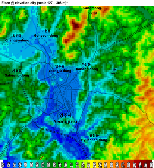
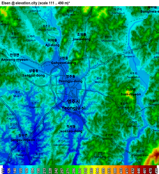
Below is the Elevation map of Eisen, which displays elevation range with different colors. Scale of the first map is from 127 to 308 m (417 to 1010 ft) with average elevation of 184.9 meters (=607 ft) [note 1]
These maps also provides idea of topography and contour of this city, they are displayed at different zoom levels. More info about maps, scale and edge coordinates you can find below images.
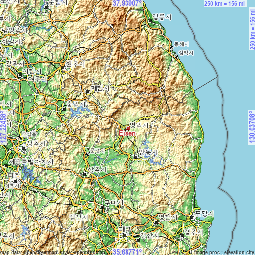
| \ | Map #1 | Map #2 | Topo.Map |
| Scale [m] | 127..308 m | 111..490 m | × |
| Scale [ft] | 417..1010 ft | 364..1608 ft | × |
| Average | 184.9 m = 607 ft | 196.2 m = 644 ft | × |
| Width | 7.82 km = 4.9 mi | 15.65 km = 9.7 mi | 250.3 km = 155.5 mi |
| Height | 7.82 km = 4.9 mi | 15.65 km = 9.7 mi | 250.3 km = 155.5 mi |
| ↑Max Latitude | 36.85684° | 36.891995° | 37.93907° |
| Latitude at center | 36.82167° | 36.82167° | 36.82167° |
| ↓Min Latitude | 36.786483° | 36.751281° | 35.68771° |
| ← Min Longitude | 128.586885° | 128.542939° | 127.22458° |
| Longitude center | 128.63083° | 128.63083° | 128.63083° |
| →Max Longitude | 128.674775° | 128.718721° | 130.03708° |
Nearby cities:
Cities around Eisen sort by population:
• Andong elevation 103 m
29.5 km,  163°
163°
• Mungyeong 78 m
46 km,  236°
236°
• Sangju 61 m
61.7 km,  222°
222°
• T’aebaek 691 m
50.6 km,  38°
38°
• Koesan 116 m
74.4 km,  269°
269°
• Kunwi 95 m
65.5 km,  184°
184°
• Cheongsong gun 197 m
57.5 km,  138°
138°
• Neietsu 208 m
42.8 km,  340°
340°
• Jenzan 48 m
71.1 km,  204°
204°
• Pyeongchang 300 m
64.5 km, 340°
• Mungyeong 169 m
47.5 km,  258°
258°
• Yecheon 92 m
24.1 km, 220°
Multilingual:
 En español:
Eisen elevación 145 m.
 En France:
Eisen élévation 145 m.


Sources and notes:
- [note 1] Map square and city borders are not equal. Map elevation data is calculated only from area inside that square.
- [src 1] Elevation data from geonames database provided with same terms of usage.
- [src 2] The elevation map of Eisen is generated using elevation data from NASA's 3 arcsec (90m) resolution SRTM data.
- [src 3] Base (background) map © OpenStreetMap contributors tiles are generated by Geofabrik and OpenTopoMap.
Copyright & License:
This Eisen Elevation Map is licensed under CC BY-SA. You may reuse any part from this page, if you give a proper credit by linking to this URL:
 More info on terms of use page.