Neietsu elevation
Neietsu (Gangwon-do), South Korea elevation is 208 meters and Neietsu elevation in feet is 682 ft above sea level [src 1]. Neietsu is a populated place (feature code) with elevation that is 136 meters (446 ft) bigger than average city elevation in South Korea.
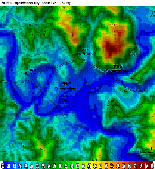
Below is the Elevation map of Neietsu, which displays elevation range with different colors. Scale of the first map is from 175 to 780 m (574 to 2559 ft) with average elevation of 311.7 meters (=1023 ft) [note 1]
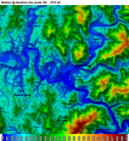
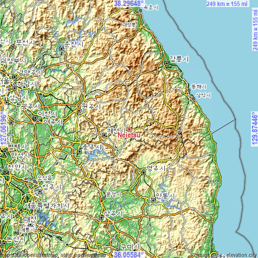
These maps also provides idea of topography and contour of this city, they are displayed at different zoom levels. More info about maps, scale and edge coordinates you can find below images.
| \ | Map #1 | Map #2 | Topo.Map |
| Scale [m] | 175..780 m | 164..1015 m | × |
| Scale [ft] | 574..2559 ft | 538..3330 ft | × |
| Average | 311.7 m = 1023 ft | 376.7 m = 1236 ft | × |
| Width | 7.79 km = 4.8 mi | 15.57 km = 9.7 mi | 249.1 km = 154.8 mi |
| Height | 7.79 km = 4.8 mi | 15.57 km = 9.7 mi | 249.1 km = 154.8 mi |
| ↑Max Latitude | 37.219473° | 37.254459° | 38.29648° |
| Latitude at center | 37.18447° | 37.18447° | 37.18447° |
| ↓Min Latitude | 37.149451° | 37.114416° | 36.05584° |
| ← Min Longitude | 128.424265° | 128.380319° | 127.06196° |
| Longitude center | 128.46821° | 128.46821° | 128.46821° |
| →Max Longitude | 128.512155° | 128.556101° | 129.87446° |
Nearby cities:
Cities around Neietsu sort by population:
• Wŏnju elevation 133 m
49.9 km,  291°
291°
• Andong 103 m
72.4 km,  161°
161°
• Tonghae 24 m
69.2 km,  54°
54°
• Eisen 145 m
42.8 km, 160°
• Mungyeong 78 m
69.8 km,  200°
200°
• T’aebaek 691 m
46.1 km,  91°
91°
• Santyoku 23 m
68.3 km,  65°
65°
• Pyeongchang 300 m
21.7 km,  342°
342°
• Gujeong 48 m
69.7 km,  31°
31°
• Seoseok 325 m
63.7 km, 337°
• Mungyeong 169 m
59.3 km,  212°
212°
• Yecheon 92 m
58.6 km,  181°
181°
Multilingual:
 En español:
Neietsu elevación 208 m.
 En France:
Neietsu élévation 208 m.


Sources and notes:
- [note 1] Map square and city borders are not equal. Map elevation data is calculated only from area inside that square.
- [src 1] Elevation data from geonames database provided with same terms of usage.
- [src 2] The elevation map of Neietsu is generated using elevation data from NASA's 3 arcsec (90m) resolution SRTM data.
- [src 3] Base (background) map © OpenStreetMap contributors tiles are generated by Geofabrik and OpenTopoMap.
Copyright & License:
This Neietsu Elevation Map is licensed under CC BY-SA. You may reuse any part from this page, if you give a proper credit by linking to this URL:
 More info on terms of use page.