Mungyeong elevation
Mungyeong (Gyeongsangbuk-do), South Korea elevation is 78 meters and Mungyeong elevation in feet is 256 ft above sea level [src 1]. Mungyeong is a populated place (feature code) with elevation that is 6 meters (20 ft) bigger than average city elevation in South Korea.
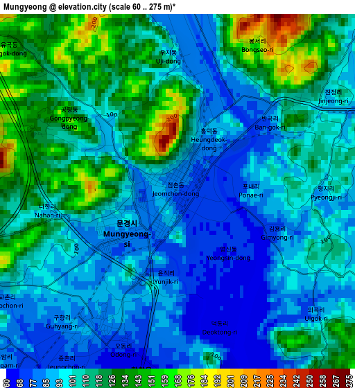
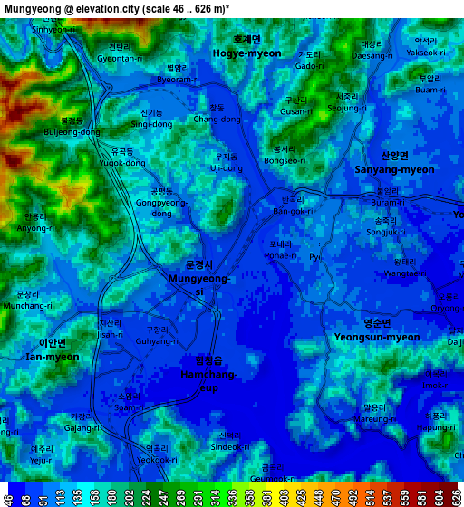
Below is the Elevation map of Mungyeong, which displays elevation range with different colors. Scale of the first map is from 60 to 275 m (197 to 902 ft) with average elevation of 106 meters (=348 ft) [note 1]
These maps also provides idea of topography and contour of this city, they are displayed at different zoom levels. More info about maps, scale and edge coordinates you can find below images.
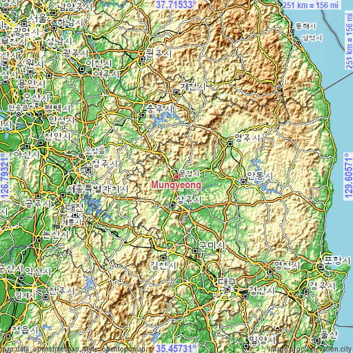
| \ | Map #1 | Map #2 | Topo.Map |
| Scale [m] | 60..275 m | 46..626 m | × |
| Scale [ft] | 197..902 ft | 151..2054 ft | × |
| Average | 106 m = 348 ft | 134.9 m = 443 ft | × |
| Width | 7.85 km = 4.9 mi | 15.69 km = 9.7 mi | 251.1 km = 156 mi |
| Height | 7.85 km = 4.9 mi | 15.69 km = 9.7 mi | 251.1 km = 156 mi |
| ↑Max Latitude | 36.629854° | 36.665113° | 37.71533° |
| Latitude at center | 36.59458° | 36.59458° | 36.59458° |
| ↓Min Latitude | 36.559289° | 36.523983° | 35.45731° |
| ← Min Longitude | 128.155515° | 128.111569° | 126.79321° |
| Longitude center | 128.19946° | 128.19946° | 128.19946° |
| →Max Longitude | 128.243405° | 128.287351° | 129.60571° |
Nearby cities:
Cities around Mungyeong sort by population:
• Andong elevation 103 m
46.8 km,  93°
93°
• Eisen 145 m
46 km,  56°
56°
• Sangju 61 m
20.2 km,  189°
189°
• Koesan 116 m
43.4 km,  303°
303°
• Jenzan 48 m
40.3 km,  167°
167°
• Hwanggan 163 m
48 km,  212°
212°
• Samseung 158 m
47.2 km,  242°
242°
• Chupungnyeong 219 m
45.9 km,  203°
203°
• Cheongsan 108 m
45.6 km,  232°
232°
• Hwanam 213 m
30.8 km, 238°
• Yecheon 92 m
23.9 km,  72°
72°
• Mungyeong 169 m
17.6 km,  332°
332°
Multilingual:
 En español:
Mungyeong elevación 78 m.
 En France:
Mungyeong élévation 78 m.
 Auf Deutsch:
Mungyeong höhe über dem Meeresspiegel ist 78 m.

Sources and notes:
- [note 1] Map square and city borders are not equal. Map elevation data is calculated only from area inside that square.
- [src 1] Elevation data from geonames database provided with same terms of usage.
- [src 2] The elevation map of Mungyeong is generated using elevation data from NASA's 3 arcsec (90m) resolution SRTM data.
- [src 3] Base (background) map © OpenStreetMap contributors tiles are generated by Geofabrik and OpenTopoMap.
Copyright & License:
This Mungyeong Elevation Map is licensed under CC BY-SA. You may reuse any part from this page, if you give a proper credit by linking to this URL:
 More info on terms of use page.