Koesan elevation
Koesan (North Chungcheong), South Korea elevation is 116 meters and Koesan elevation in feet is 381 ft above sea level [src 1]. Koesan is a populated place (feature code) with elevation that is 44 meters (144 ft) bigger than average city elevation in South Korea.
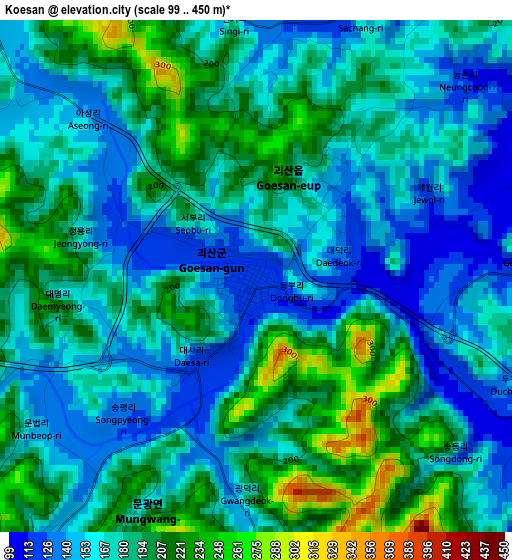
Below is the Elevation map of Koesan, which displays elevation range with different colors. Scale of the first map is from 99 to 450 m (325 to 1476 ft) with average elevation of 176.8 meters (=580 ft) [note 1]
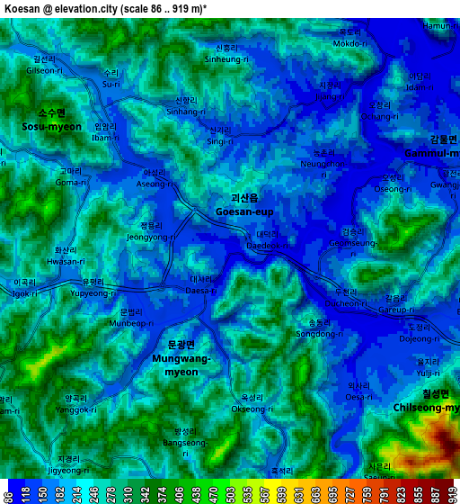
These maps also provides idea of topography and contour of this city, they are displayed at different zoom levels. More info about maps, scale and edge coordinates you can find below images.
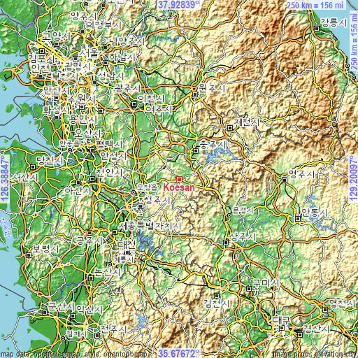
| \ | Map #1 | Map #2 | Topo.Map |
| Scale [m] | 99..450 m | 86..919 m | × |
| Scale [ft] | 325..1476 ft | 282..3015 ft | × |
| Average | 176.8 m = 580 ft | 229.5 m = 753 ft | × |
| Width | 7.82 km = 4.9 mi | 15.65 km = 9.7 mi | 250.4 km = 155.6 mi |
| Height | 7.82 km = 4.9 mi | 15.65 km = 9.7 mi | 250.4 km = 155.6 mi |
| ↑Max Latitude | 36.846005° | 36.881164° | 37.92839° |
| Latitude at center | 36.81083° | 36.81083° | 36.81083° |
| ↓Min Latitude | 36.775639° | 36.740431° | 35.67672° |
| ← Min Longitude | 127.750775° | 127.706829° | 126.38847° |
| Longitude center | 127.79472° | 127.79472° | 127.79472° |
| →Max Longitude | 127.838665° | 127.882611° | 129.20097° |
Nearby cities:
Cities around Koesan sort by population:
• Cheongju-si elevation 49 m
33.3 km,  234°
234°
• Sejong 49 m
51 km,  241°
241°
• Mungyeong 78 m
43.4 km,  123°
123°
• Chinch'ŏn 69 m
31.7 km,  279°
279°
• Sintansin 40 m
51.3 km,  219°
219°
• Annam 86 m
51.6 km,  192°
192°
• Cheongsan 108 m
51.6 km,  180°
180°
• Annae 87 m
47.8 km, 194°
• Samseung 158 m
46.4 km, 186°
• Hoenam 93 m
45 km,  205°
205°
• Hwanam 213 m
41.5 km,  166°
166°
• Mungyeong 169 m
29.2 km,  106°
106°
Multilingual:
 En español:
Koesan elevación 116 m.
 En France:
Koesan élévation 116 m.


Sources and notes:
- [note 1] Map square and city borders are not equal. Map elevation data is calculated only from area inside that square.
- [src 1] Elevation data from geonames database provided with same terms of usage.
- [src 2] The elevation map of Koesan is generated using elevation data from NASA's 3 arcsec (90m) resolution SRTM data.
- [src 3] Base (background) map © OpenStreetMap contributors tiles are generated by Geofabrik and OpenTopoMap.
Copyright & License:
This Koesan Elevation Map is licensed under CC BY-SA. You may reuse any part from this page, if you give a proper credit by linking to this URL:
 More info on terms of use page.