Tsuma elevation
Tsuma (Miyazaki, Saito-shi), Japan elevation is 11 meters and Tsuma elevation in feet is 36 ft above sea level [src 1]. Tsuma is a populated place (feature code) with elevation that is 74 meters (243 ft) smaller than average city elevation in Japan.
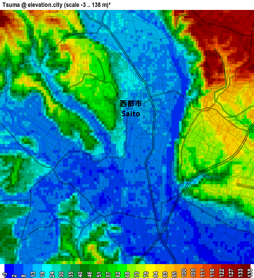
Below is the Elevation map of Tsuma, which displays elevation range with different colors. Scale of the first map is from -3 to 138 m (-10 to 453 ft) with average elevation of 38.2 meters (=125 ft) [note 1]
These maps also provides idea of topography and contour of this city, they are displayed at different zoom levels. More info about maps, scale and edge coordinates you can find below images.
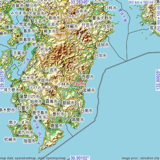
| \ | Map #1 | Map #2 | Topo.Map |
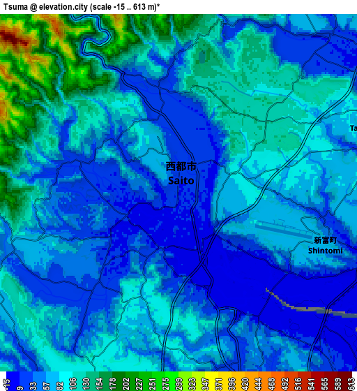
| Scale [m] | -3..138 m | -15..613 m | × |
| Scale [ft] | -10..453 ft | -49..2011 ft | × |
| Average | 38.2 m = 125 ft | 74.7 m = 245 ft | × |
| Width | 8.28 km = 5.1 mi | 16.56 km = 10.3 mi | 264.9 km = 164.6 mi |
| Height | 8.28 km = 5.1 mi | 16.56 km = 10.3 mi | 264.9 km = 164.6 mi |
| ↑Max Latitude | 32.137219° | 32.174424° | 33.28345° |
| Latitude at center | 32.1° | 32.1° | 32.1° |
| ↓Min Latitude | 32.062765° | 32.025516° | 30.90102° |
| ← Min Longitude | 131.356055° | 131.312109° | 129.99375° |
| Longitude center | 131.4° | 131.4° | 131.4° |
| →Max Longitude | 131.443945° | 131.487891° | 132.80625° |
Nearby cities:
Cities around Tsuma sort by population:
• Miyazaki elevation 11 m
20.4 km,  175°
175°
• Miyakonojō 148 m
51.5 km,  217°
217°
• Nobeoka 4 m
59.3 km,  24°
24°
• Nichinan 29 m
55.7 km, 183°
• Kobayashi 205 m
41.4 km,  251°
251°
• Hitoyoshi 130 m
62.5 km,  281°
281°
• Takanabe 11 m
10.1 km,  68°
68°
• Sueyoshichō-ninokata 188 m
61.8 km, 215°
• Soo 217 m
63.5 km, 217°
• Ebino 239 m
52.7 km,  263°
263°
• Hyūga 4 m
42.4 km,  32°
32°
• Saito 8 m
2 km, 181°
Multilingual:
 En español:
Tsuma elevación 11 m.
 En France:
Tsuma élévation 11 m.


Sources and notes:
- [note 1] Map square and city borders are not equal. Map elevation data is calculated only from area inside that square.
- [src 1] Elevation data from geonames database provided with same terms of usage.
- [src 2] The elevation map of Tsuma is generated using elevation data from NASA's 3 arcsec (90m) resolution SRTM data.
- [src 3] Base (background) map © OpenStreetMap contributors tiles are generated by Geofabrik and OpenTopoMap.
Copyright & License:
This Tsuma Elevation Map is licensed under CC BY-SA. You may reuse any part from this page, if you give a proper credit by linking to this URL:
 More info on terms of use page.