Kobayashi elevation
Kobayashi (Miyazaki, Kobayashi Shi), Japan elevation is 205 meters and Kobayashi elevation in feet is 673 ft above sea level [src 1]. Kobayashi is a seat of a second-order administrative division (feature code) with elevation that is 120 meters (394 ft) bigger than average city elevation in Japan.
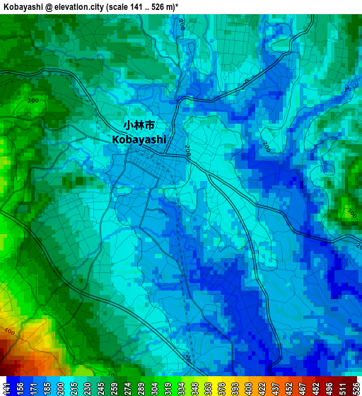
Below is the Elevation map of Kobayashi, which displays elevation range with different colors. Scale of the first map is from 141 to 526 m (463 to 1726 ft) with average elevation of 222.2 meters (=729 ft) [note 1]
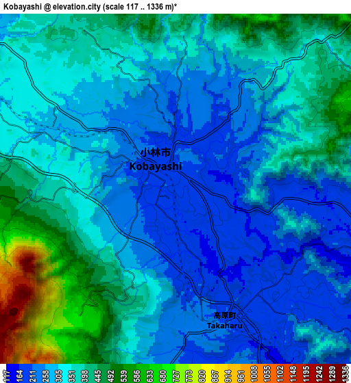
These maps also provides idea of topography and contour of this city, they are displayed at different zoom levels. More info about maps, scale and edge coordinates you can find below images.
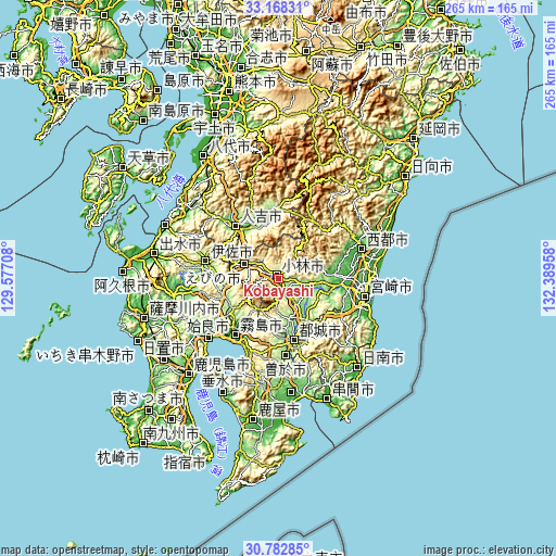
| \ | Map #1 | Map #2 | Topo.Map |
| Scale [m] | 141..526 m | 117..1336 m | × |
| Scale [ft] | 463..1726 ft | 384..4383 ft | × |
| Average | 222.2 m = 729 ft | 339.6 m = 1114 ft | × |
| Width | 8.29 km = 5.2 mi | 16.58 km = 10.3 mi | 265.2 km = 164.8 mi |
| Height | 8.29 km = 5.2 mi | 16.58 km = 10.3 mi | 265.2 km = 164.8 mi |
| ↑Max Latitude | 32.020597° | 32.057849° | 33.16831° |
| Latitude at center | 31.98333° | 31.98333° | 31.98333° |
| ↓Min Latitude | 31.946048° | 31.908751° | 30.78285° |
| ← Min Longitude | 130.939385° | 130.895439° | 129.57708° |
| Longitude center | 130.98333° | 130.98333° | 130.98333° |
| →Max Longitude | 131.027275° | 131.071221° | 132.38958° |
Nearby cities:
Cities around Kobayashi sort by population:
• Miyakonojō elevation 148 m
28.9 km,  164°
164°
• Kokubu-matsuki 0 m
34.5 km,  216°
216°
• Hamanoichi -1 m
37.9 km, 218°
• Hitoyoshi 130 m
34 km,  319°
319°
• Kajiki 3 m
40.8 km,  227°
227°
• Ōkuchi-shinohara 182 m
35.1 km,  285°
285°
• Sueyoshichō-ninokata 188 m
37.2 km,  175°
175°
• Saito 8 m
40.7 km,  74°
74°
• Soo 217 m
37.5 km, 178°
• Isa 183 m
36.2 km,  284°
284°
• Kirishima 10 m
34.1 km, 217°
• Ebino 239 m
14.9 km,  298°
298°
Multilingual:
 En español:
Kobayashi elevación 205 m.
 En France:
Kobayashi élévation 205 m.
 Auf Deutsch:
Kobayashi höhe über dem Meeresspiegel ist 205 m.

Sources and notes:
- [note 1] Map square and city borders are not equal. Map elevation data is calculated only from area inside that square.
- [src 1] Elevation data from geonames database provided with same terms of usage.
- [src 2] The elevation map of Kobayashi is generated using elevation data from NASA's 3 arcsec (90m) resolution SRTM data.
- [src 3] Base (background) map © OpenStreetMap contributors tiles are generated by Geofabrik and OpenTopoMap.
Copyright & License:
This Kobayashi Elevation Map is licensed under CC BY-SA. You may reuse any part from this page, if you give a proper credit by linking to this URL:
 More info on terms of use page.