Ebino elevation
Ebino (Miyazaki, Ebino-shi), Japan elevation is 239 meters and Ebino elevation in feet is 784 ft above sea level [src 1]. Ebino is a seat of a second-order administrative division (feature code) with elevation that is 154 meters (505 ft) bigger than average city elevation in Japan.
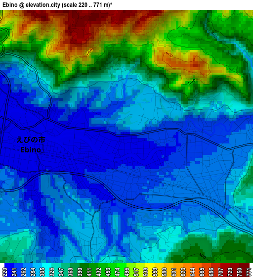
Below is the Elevation map of Ebino, which displays elevation range with different colors. Scale of the first map is from 220 to 771 m (722 to 2530 ft) with average elevation of 343.3 meters (=1126 ft) [note 1]
These maps also provides idea of topography and contour of this city, they are displayed at different zoom levels. More info about maps, scale and edge coordinates you can find below images.
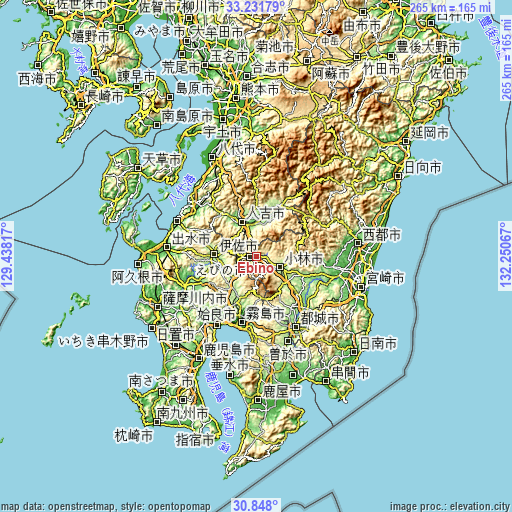
| \ | Map #1 | Topo.Map |
| Scale [m] | 220..771 m | × |
| Scale [ft] | 722..2530 ft | × |
| Average | 343.3 m = 1126 ft | × |
| Width | 8.28 km = 5.1 mi | 265.1 km = 164.7 mi |
| Height | 8.28 km = 5.1 mi | 265.1 km = 164.7 mi |
| ↑Max Latitude | 32.084901° | 33.23179° |
| Latitude at center | 32.04766° | 32.04766° |
| ↓Min Latitude | 32.010404° | 30.848° |
| ← Min Longitude | 130.800475° | 129.43817° |
| Longitude center | 130.84442° | 130.84442° |
| →Max Longitude | 130.888365° | 132.25067° |
Nearby cities:
Cities around Ebino sort by population:
• Miyakonojō elevation 148 m
40.8 km,  149°
149°
• Kokubu-matsuki 0 m
35.7 km,  191°
191°
• Kobayashi 205 m
14.9 km,  118°
118°
• Hamanoichi -1 m
38.3 km,  195°
195°
• Izumi 37 m
45.2 km,  275°
275°
• Hitoyoshi 130 m
20.8 km,  334°
334°
• Minamata 2 m
45.9 km,  294°
294°
• Kajiki 3 m
38.8 km,  205°
205°
• Ōkuchi-shinohara 182 m
20.9 km, 276°
• Aira 76 m
38.6 km,  218°
218°
• Kirishima 10 m
35 km, 192°
• Isa 183 m
22 km, 275°
Multilingual:
 En español:
Ebino elevación 239 m.
 En France:
Ebino élévation 239 m.


Sources and notes:
- [note 1] Map square and city borders are not equal. Map elevation data is calculated only from area inside that square.
- [src 1] Elevation data from geonames database provided with same terms of usage.
- [src 2] The elevation map of Ebino is generated using elevation data from NASA's 3 arcsec (90m) resolution SRTM data.
- [src 3] Base (background) map © OpenStreetMap contributors tiles are generated by Geofabrik and OpenTopoMap.
Copyright & License:
This Ebino Elevation Map is licensed under CC BY-SA. You may reuse any part from this page, if you give a proper credit by linking to this URL:
 More info on terms of use page.