Uenohara elevation
Uenohara (Yamanashi, Uenohara-shi), Japan elevation is 165 meters and Uenohara elevation in feet is 541 ft above sea level [src 1]. Uenohara is a seat of a second-order administrative division (feature code) with elevation that is 80 meters (262 ft) bigger than average city elevation in Japan.
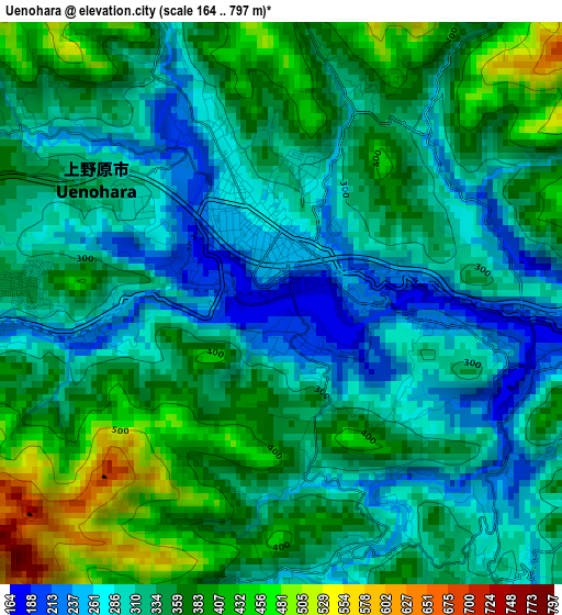
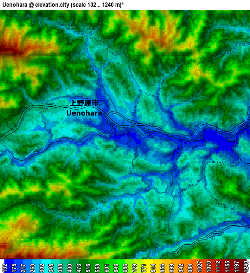
Below is the Elevation map of Uenohara, which displays elevation range with different colors. Scale of the first map is from 164 to 797 m (538 to 2615 ft) with average elevation of 335.6 meters (=1101 ft) [note 1]
These maps also provides idea of topography and contour of this city, they are displayed at different zoom levels. More info about maps, scale and edge coordinates you can find below images.
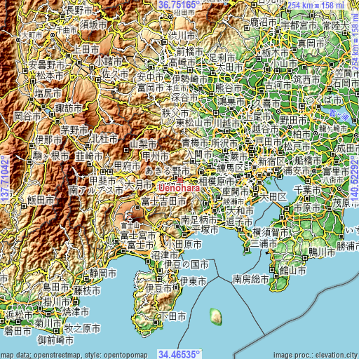
| \ | Map #1 | Map #2 | Topo.Map |
| Scale [m] | 164..797 m | 132..1240 m | × |
| Scale [ft] | 538..2615 ft | 433..4068 ft | × |
| Average | 335.6 m = 1101 ft | 469.9 m = 1542 ft | × |
| Width | 7.94 km = 4.9 mi | 15.89 km = 9.9 mi | 254.2 km = 158 mi |
| Height | 7.94 km = 4.9 mi | 15.89 km = 9.9 mi | 254.2 km = 158 mi |
| ↑Max Latitude | 35.652387° | 35.688087° | 36.75165° |
| Latitude at center | 35.61667° | 35.61667° | 35.61667° |
| ↓Min Latitude | 35.580938° | 35.545189° | 34.46535° |
| ← Min Longitude | 139.072725° | 139.028779° | 137.71042° |
| Longitude center | 139.11667° | 139.11667° | 139.11667° |
| →Max Longitude | 139.160615° | 139.204561° | 140.52292° |
Nearby cities:
Cities around Uenohara sort by population:
• Hachiōji elevation 127 m
19.2 km,  76°
76°
• Hino 85 m
26.4 km, 76°
• Ōme 189 m
21.8 km,  31°
31°
• Fussa 117 m
23 km,  54°
54°
• Ōtsuki 360 m
12.9 km,  270°
270°
• Itsukaichi 184 m
15.1 km,  37°
37°
• Yamakita 144 m
28.4 km,  186°
186°
• Akishima 110 m
26.5 km,  64°
64°
• Hamura 154 m
24.5 km, 48°
• Tsuru 596 m
20.3 km,  247°
247°
• Akiruno 163 m
16.2 km, 39°
• Sagamihara 236 m
12.6 km,  116°
116°
Multilingual:
 En español:
Uenohara elevación 165 m.
 En France:
Uenohara élévation 165 m.
 Auf Deutsch:
Uenohara höhe über dem Meeresspiegel ist 165 m.

Sources and notes:
- [note 1] Map square and city borders are not equal. Map elevation data is calculated only from area inside that square.
- [src 1] Elevation data from geonames database provided with same terms of usage.
- [src 2] The elevation map of Uenohara is generated using elevation data from NASA's 3 arcsec (90m) resolution SRTM data.
- [src 3] Base (background) map © OpenStreetMap contributors tiles are generated by Geofabrik and OpenTopoMap.
Copyright & License:
This Uenohara Elevation Map is licensed under CC BY-SA. You may reuse any part from this page, if you give a proper credit by linking to this URL:
 More info on terms of use page.