Ōme elevation
Ōme (Tokyo, Ōme-shi), Japan elevation is 189 meters and Ōme elevation in feet is 620 ft above sea level [src 1]. Ōme is a seat of a second-order administrative division (feature code) with elevation that is 104 meters (341 ft) bigger than average city elevation in Japan.
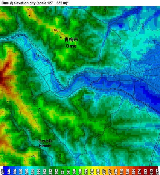
Below is the Elevation map of Ōme, which displays elevation range with different colors. Scale of the first map is from 127 to 632 m (417 to 2073 ft) with average elevation of 272 meters (=892 ft) [note 1]
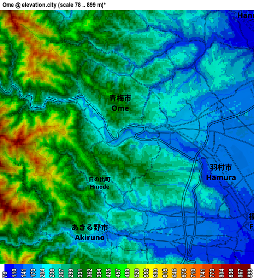
These maps also provides idea of topography and contour of this city, they are displayed at different zoom levels. More info about maps, scale and edge coordinates you can find below images.
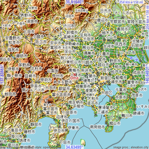
| \ | Map #1 | Map #2 | Topo.Map |
| Scale [m] | 127..632 m | 78..899 m | × |
| Scale [ft] | 417..2073 ft | 256..2949 ft | × |
| Average | 272 m = 892 ft | 292.4 m = 959 ft | × |
| Width | 7.93 km = 4.9 mi | 15.86 km = 9.9 mi | 253.7 km = 157.6 mi |
| Height | 7.93 km = 4.9 mi | 15.86 km = 9.9 mi | 253.7 km = 157.6 mi |
| ↑Max Latitude | 35.819532° | 35.855157° | 36.91646° |
| Latitude at center | 35.78389° | 35.78389° | 35.78389° |
| ↓Min Latitude | 35.748232° | 35.712559° | 34.63495° |
| ← Min Longitude | 139.199115° | 139.155169° | 137.83681° |
| Longitude center | 139.24306° | 139.24306° | 139.24306° |
| →Max Longitude | 139.287005° | 139.330951° | 140.64931° |
Nearby cities:
Cities around Ōme sort by population:
• Hachiōji elevation 127 m
16 km,  152°
152°
• Sayama 81 m
17.1 km,  63°
63°
• Hannō 113 m
10.1 km,  41°
41°
• Fussa 117 m
9 km,  125°
125°
• Morohongō 125 m
17.7 km,  18°
18°
• Itsukaichi 184 m
6.9 km,  199°
199°
• Musashimurayama 99 m
17.2 km,  105°
105°
• Higashiyamato 97 m
17.2 km,  102°
102°
• Akishima 110 m
14.2 km,  119°
119°
• Iruma 126 m
11.9 km,  71°
71°
• Hamura 154 m
7.3 km, 109°
• Akiruno 163 m
6.2 km,  189°
189°
Multilingual:
 En español:
Ōme elevación 189 m.
 En France:
Oume élévation 189 m.


Sources and notes:
- [note 1] Map square and city borders are not equal. Map elevation data is calculated only from area inside that square.
- [src 1] Elevation data from geonames database provided with same terms of usage.
- [src 2] The elevation map of Ōme is generated using elevation data from NASA's 3 arcsec (90m) resolution SRTM data.
- [src 3] Base (background) map © OpenStreetMap contributors tiles are generated by Geofabrik and OpenTopoMap.
Copyright & License:
This Ōme Elevation Map is licensed under CC BY-SA. You may reuse any part from this page, if you give a proper credit by linking to this URL:
 More info on terms of use page.