Sagamihara elevation
Sagamihara (Kanagawa, Sagamihara-shi), Japan elevation is 236 meters and Sagamihara elevation in feet is 774 ft above sea level [src 1]. Sagamihara is a seat of a second-order administrative division (feature code) with elevation that is 151 meters (495 ft) bigger than average city elevation in Japan.
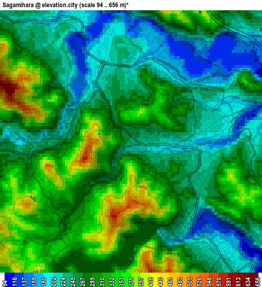
Below is the Elevation map of Sagamihara, which displays elevation range with different colors. Scale of the first map is from 94 to 656 m (308 to 2152 ft) with average elevation of 276.2 meters (=906 ft) [note 1]
These maps also provides idea of topography and contour of this city, they are displayed at different zoom levels. More info about maps, scale and edge coordinates you can find below images.
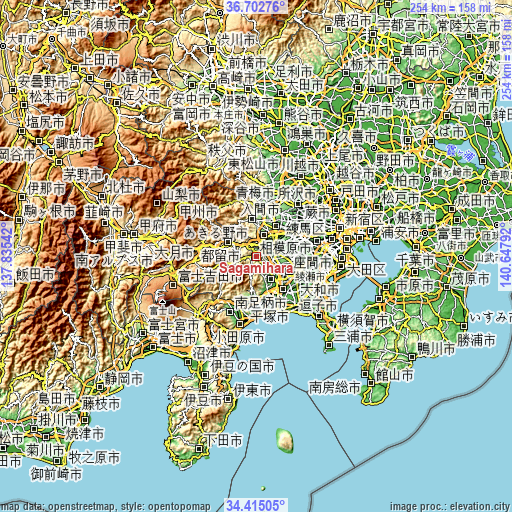
| \ | Map #1 | Topo.Map |
| Scale [m] | 94..656 m | × |
| Scale [ft] | 308..2152 ft | × |
| Average | 276.2 m = 906 ft | × |
| Width | 7.95 km = 4.9 mi | 254.4 km = 158.1 mi |
| Height | 7.95 km = 4.9 mi | 254.4 km = 158.1 mi |
| ↑Max Latitude | 35.602809° | 36.70276° |
| Latitude at center | 35.56707° | 35.56707° |
| ↓Min Latitude | 35.531315° | 34.41505° |
| ← Min Longitude | 139.197725° | 137.83542° |
| Longitude center | 139.24167° | 139.24167° |
| →Max Longitude | 139.285615° | 140.64792° |
Nearby cities:
Cities around Sagamihara sort by population:
• Hachiōji elevation 127 m
12.4 km,  36°
36°
• Machida 103 m
19.2 km,  98°
98°
• Atsugi 26 m
18 km,  140°
140°
• Minamirinkan 79 m
19.9 km,  113°
113°
• Hino 85 m
18.6 km,  50°
50°
• Zama 32 m
16.1 km,  123°
123°
• Isehara 35 m
19.7 km,  161°
161°
• Fussa 117 m
20.3 km,  21°
21°
• Uenohara 165 m
12.6 km,  296°
296°
• Itsukaichi 184 m
17.7 km,  353°
353°
• Ebina 35 m
20.2 km, 136°
• Akiruno 163 m
18 km,  357°
357°
Multilingual:
 En español:
Sagamihara elevación 236 m.
 En France:
Sagamihara élévation 236 m.
 Auf Deutsch:
Sagamihara höhe über dem Meeresspiegel ist 236 m.

Sources and notes:
- [note 1] Map square and city borders are not equal. Map elevation data is calculated only from area inside that square.
- [src 1] Elevation data from geonames database provided with same terms of usage.
- [src 2] The elevation map of Sagamihara is generated using elevation data from NASA's 3 arcsec (90m) resolution SRTM data.
- [src 3] Base (background) map © OpenStreetMap contributors tiles are generated by Geofabrik and OpenTopoMap.
Copyright & License:
This Sagamihara Elevation Map is licensed under CC BY-SA. You may reuse any part from this page, if you give a proper credit by linking to this URL:
 More info on terms of use page.