Ar Ramthā elevation
Ar Ramthā (Irbid), Jordan elevation is 536 meters and Ar Ramthā elevation in feet is 1759 ft above sea level [src 1]. Ar Ramthā is a seat of a second-order administrative division (feature code) with elevation that is 156 meters (512 ft) smaller than average city elevation in Jordan.
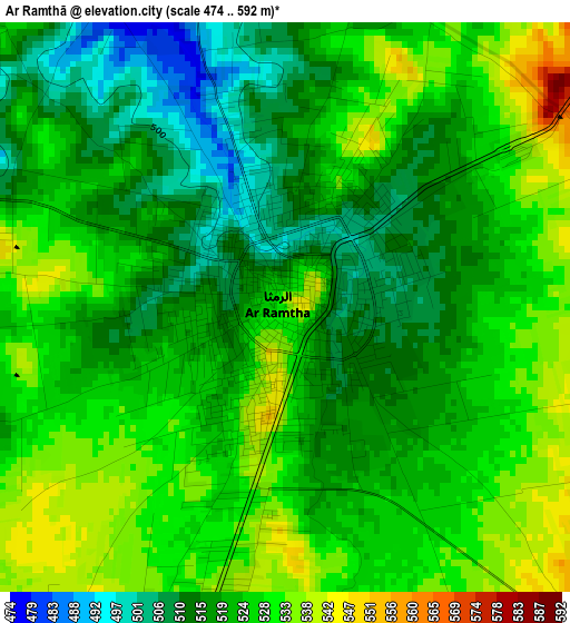
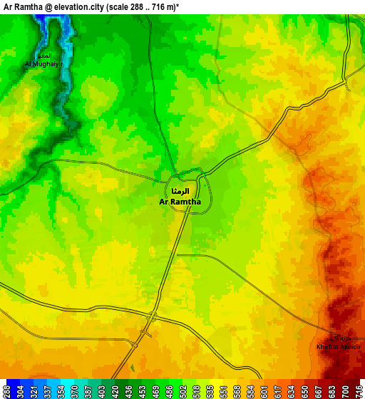
Below is the Elevation map of Ar Ramthā, which displays elevation range with different colors. Scale of the first map is from 474 to 592 m (1555 to 1942 ft) with average elevation of 522.6 meters (=1715 ft) [note 1]
These maps also provides idea of topography and contour of this city, they are displayed at different zoom levels. More info about maps, scale and edge coordinates you can find below images.
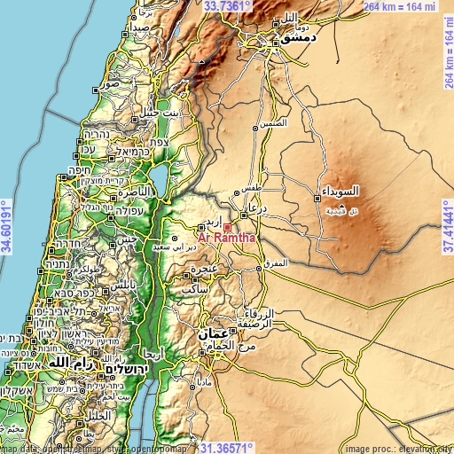
| \ | Map #1 | Map #2 | Topo.Map |
| Scale [m] | 474..592 m | 288..716 m | × |
| Scale [ft] | 1555..1942 ft | 945..2349 ft | × |
| Average | 522.6 m = 1715 ft | 535.2 m = 1756 ft | × |
| Width | 8.24 km = 5.1 mi | 16.47 km = 10.2 mi | 263.6 km = 163.8 mi |
| Height | 8.24 km = 5.1 mi | 16.47 km = 10.2 mi | 263.6 km = 163.8 mi |
| ↑Max Latitude | 32.595761° | 32.632777° | 33.7361° |
| Latitude at center | 32.55873° | 32.55873° | 32.55873° |
| ↓Min Latitude | 32.521683° | 32.484622° | 31.36571° |
| ← Min Longitude | 35.964215° | 35.920269° | 34.60191° |
| Longitude center | 36.00816° | 36.00816° | 36.00816° |
| →Max Longitude | 36.052105° | 36.096051° | 37.41441° |
Nearby cities:
Cities around Ar Ramthā sort by population:
• Irbid elevation 570 m
14.8 km,  268°
268°
• Aydūn 657 m
15.3 km,  247°
247°
• Aţ Ţurrah 466 m
9.2 km,  348°
348°
• Ash Shajarah 454 m
11.3 km,  326°
326°
• Ḩakamā 550 m
12.3 km,  288°
288°
• Sāl 571 m
9.1 km,  277°
277°
• Al Ḩamrā’ 697 m
18.9 km,  134°
134°
• Kharjā 449 m
15.9 km,  314°
314°
• Kitim 791 m
17 km,  217°
217°
• Sammā ar Rawsān 556 m
19.2 km,  297°
297°
• Ḩawshā 735 m
14.7 km,  144°
144°
• Al Ḩişn 639 m
14.3 km,  234°
234°
Multilingual:
 En español:
Ar Ramthā elevación 536 m.
 En France:
Ar Ramthā élévation 536 m.
 Auf Deutsch:
Ar Ramthā höhe über dem Meeresspiegel ist 536 m.

Sources and notes:
- [note 1] Map square and city borders are not equal. Map elevation data is calculated only from area inside that square.
- [src 1] Elevation data from geonames database provided with same terms of usage.
- [src 2] The elevation map of Ar Ramthā is generated using elevation data from NASA's 3 arcsec (90m) resolution SRTM data.
- [src 3] Base (background) map © OpenStreetMap contributors tiles are generated by Geofabrik and OpenTopoMap.
Copyright & License:
This Ar Ramthā Elevation Map is licensed under CC BY-SA. You may reuse any part from this page, if you give a proper credit by linking to this URL:
 More info on terms of use page.