Kitim elevation
Kitim (Irbid), Jordan elevation is 791 meters and Kitim elevation in feet is 2595 ft above sea level [src 1]. Kitim is a populated place (feature code) with elevation that is 99 meters (325 ft) bigger than average city elevation in Jordan.
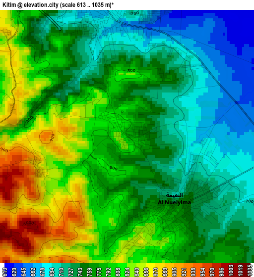
Below is the Elevation map of Kitim, which displays elevation range with different colors. Scale of the first map is from 613 to 1035 m (2011 to 3396 ft) with average elevation of 770.8 meters (=2529 ft) [note 1]
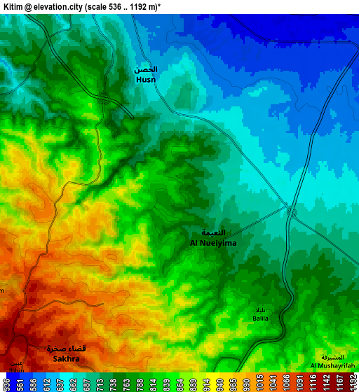
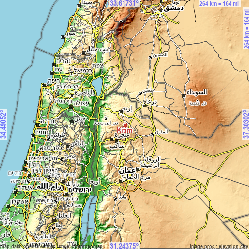
These maps also provides idea of topography and contour of this city, they are displayed at different zoom levels. More info about maps, scale and edge coordinates you can find below images.
| \ | Map #1 | Map #2 | Topo.Map |
| Scale [m] | 613..1035 m | 536..1192 m | × |
| Scale [ft] | 2011..3396 ft | 1759..3911 ft | × |
| Average | 770.8 m = 2529 ft | 782 m = 2566 ft | × |
| Width | 8.25 km = 5.1 mi | 16.5 km = 10.3 mi | 263.9 km = 164 mi |
| Height | 8.25 km = 5.1 mi | 16.5 km = 10.3 mi | 263.9 km = 164 mi |
| ↑Max Latitude | 32.475421° | 32.512486° | 33.61731° |
| Latitude at center | 32.43834° | 32.43834° | 32.43834° |
| ↓Min Latitude | 32.401244° | 32.364133° | 31.24375° |
| ← Min Longitude | 35.852825° | 35.808879° | 34.49052° |
| Longitude center | 35.89677° | 35.89677° | 35.89677° |
| →Max Longitude | 35.940715° | 35.984661° | 37.30302° |
Nearby cities:
Cities around Kitim sort by population:
• Irbid elevation 570 m
13.8 km,  341°
341°
• Aydūn 657 m
8.3 km,  334°
334°
• Sūf 965 m
14.9 km,  202°
202°
• Şakhrah 1083 m
9.1 km,  214°
214°
• Bayt Yāfā 582 m
14 km,  312°
312°
• Sāl 571 m
14.6 km,  5°
5°
• Dayr Yūsuf 752 m
10.9 km,  299°
299°
• Balīlā 796 m
6.5 km,  143°
143°
• Qafqafā 998 m
10.7 km,  158°
158°
• ‘Irjān 651 m
16.1 km,  252°
252°
• Al Mazār ash Shamālī 831 m
10 km,  290°
290°
• Al Ḩişn 639 m
5.3 km,  346°
346°
Multilingual:
 En español:
Kitim elevación 791 m.
 En France:
Kitim élévation 791 m.


Sources and notes:
- [note 1] Map square and city borders are not equal. Map elevation data is calculated only from area inside that square.
- [src 1] Elevation data from geonames database provided with same terms of usage.
- [src 2] The elevation map of Kitim is generated using elevation data from NASA's 3 arcsec (90m) resolution SRTM data.
- [src 3] Base (background) map © OpenStreetMap contributors tiles are generated by Geofabrik and OpenTopoMap.
Copyright & License:
This Kitim Elevation Map is licensed under CC BY-SA. You may reuse any part from this page, if you give a proper credit by linking to this URL:
 More info on terms of use page.