Kharjā elevation
Kharjā (Irbid), Jordan elevation is 449 meters and Kharjā elevation in feet is 1473 ft above sea level [src 1]. Kharjā is a populated place (feature code) with elevation that is 243 meters (797 ft) smaller than average city elevation in Jordan.
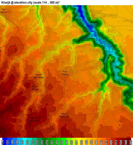
Below is the Elevation map of Kharjā, which displays elevation range with different colors. Scale of the first map is from 114 to 565 m (374 to 1854 ft) with average elevation of 437.2 meters (=1434 ft) [note 1]
These maps also provides idea of topography and contour of this city, they are displayed at different zoom levels. More info about maps, scale and edge coordinates you can find below images.
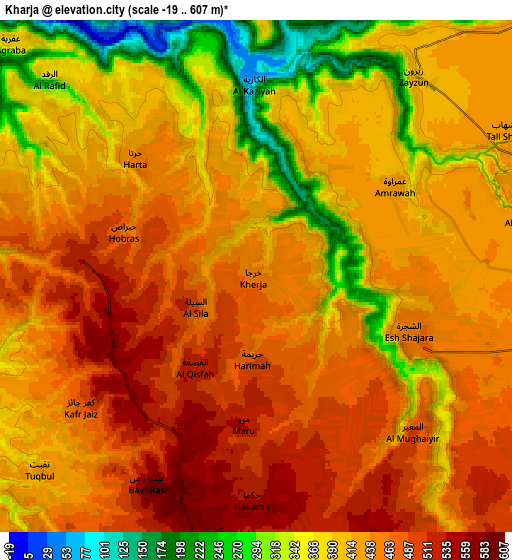
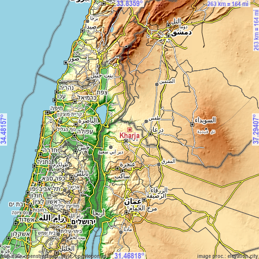
| \ | Map #1 | Map #2 | Topo.Map |
| Scale [m] | 114..565 m | -19..607 m | × |
| Scale [ft] | 374..1854 ft | -62..1991 ft | × |
| Average | 437.2 m = 1434 ft | 422.4 m = 1386 ft | × |
| Width | 8.23 km = 5.1 mi | 16.45 km = 10.2 mi | 263.3 km = 163.6 mi |
| Height | 8.23 km = 5.1 mi | 16.45 km = 10.2 mi | 263.3 km = 163.6 mi |
| ↑Max Latitude | 32.696869° | 32.733843° | 33.8359° |
| Latitude at center | 32.65988° | 32.65988° | 32.65988° |
| ↓Min Latitude | 32.622875° | 32.585855° | 31.46818° |
| ← Min Longitude | 35.843875° | 35.799929° | 34.48157° |
| Longitude center | 35.88782° | 35.88782° | 35.88782° |
| →Max Longitude | 35.931765° | 35.975711° | 37.29407° |
Nearby cities:
Cities around Kharjā sort by population:
• Irbid elevation 570 m
12.1 km,  196°
196°
• Ar Ramthā 536 m
15.9 km,  134°
134°
• Aţ Ţurrah 466 m
9.8 km,  103°
103°
• Ash Shajarah 454 m
5.4 km,  109°
109°
• Kafr Sawm 435 m
8.6 km,  289°
289°
• Ḩakamā 550 m
7.4 km,  183°
183°
• Sāl 571 m
10.4 km,  167°
167°
• Malkā 420 m
13.2 km,  278°
278°
• Saḩam al Kaffārāt 402 m
11.5 km, 292°
• Ḩātim 420 m
10.4 km,  260°
260°
• Zaḩar 437 m
14.6 km,  224°
224°
• Sammā ar Rawsān 556 m
6.2 km,  246°
246°
Multilingual:
 En español:
Kharjā elevación 449 m.
 En France:
Kharjā élévation 449 m.


Sources and notes:
- [note 1] Map square and city borders are not equal. Map elevation data is calculated only from area inside that square.
- [src 1] Elevation data from geonames database provided with same terms of usage.
- [src 2] The elevation map of Kharjā is generated using elevation data from NASA's 3 arcsec (90m) resolution SRTM data.
- [src 3] Base (background) map © OpenStreetMap contributors tiles are generated by Geofabrik and OpenTopoMap.
Copyright & License:
This Kharjā Elevation Map is licensed under CC BY-SA. You may reuse any part from this page, if you give a proper credit by linking to this URL:
 More info on terms of use page.