Fabro Scalo elevation
Fabro Scalo (Umbria, Provincia di Terni), Italy elevation is 247 meters and Fabro Scalo elevation in feet is 810 ft above sea level [src 1]. Fabro Scalo is a populated place (feature code) with elevation that is 75 meters (246 ft) smaller than average city elevation in Italy.
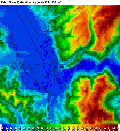
Below is the Elevation map of Fabro Scalo, which displays elevation range with different colors. Scale of the first map is from 224 to 492 m (735 to 1614 ft) with average elevation of 310.6 meters (=1019 ft) [note 1]
These maps also provides idea of topography and contour of this city, they are displayed at different zoom levels. More info about maps, scale and edge coordinates you can find below images.
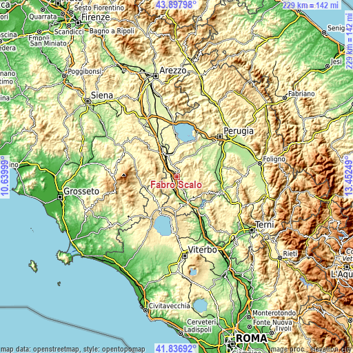
| \ | Map #1 | Topo.Map |
| Scale [m] | 224..492 m | × |
| Scale [ft] | 735..1614 ft | × |
| Average | 310.6 m = 1019 ft | × |
| Width | 7.16 km = 4.4 mi | 229.2 km = 142.4 mi |
| Height | 7.16 km = 4.4 mi | 229.2 km = 142.4 mi |
| ↑Max Latitude | 42.908246° | 43.89798° |
| Latitude at center | 42.87605° | 42.87605° |
| ↓Min Latitude | 42.843837° | 41.83692° |
| ← Min Longitude | 12.002295° | 10.63999° |
| Longitude center | 12.04624° | 12.04624° |
| →Max Longitude | 12.090185° | 13.45249° |
Nearby cities:
Cities around Fabro Scalo sort by population:
• Chiusi Scalo elevation 266 m
15.3 km,  330°
330°
• Città della Pieve 484 m
9.8 km,  340°
340°
• Stazione di Allerona 189 m
10.1 km,  184°
184°
• Castel Viscardo 494 m
14.1 km,  195°
195°
• Fabro 262 m
2.5 km,  261°
261°
• Ficulle 454 m
5.2 km,  160°
160°
• Piegaro 353 m
10.5 km,  17°
17°
• Montegabbione 567 m
6.1 km,  37°
37°
• Monteleone d'Orvieto 493 m
5.1 km,  6°
6°
• San Casciano dei Bagni 565 m
13.8 km,  267°
267°
• Allerona 449 m
9.2 km,  219°
219°
• Parrano 456 m
5.3 km,  101°
101°
Multilingual:
 En español:
Fabro Scalo elevación 247 m.
 En France:
Fabro Scalo élévation 247 m.
 Auf Deutsch:
Fabro Scalo höhe über dem Meeresspiegel ist 247 m.

Sources and notes:
- [note 1] Map square and city borders are not equal. Map elevation data is calculated only from area inside that square.
- [src 1] Elevation data from geonames database provided with same terms of usage.
- [src 2] The elevation map of Fabro Scalo is generated using elevation data from NASA's 3 arcsec (90m) resolution SRTM data.
- [src 3] Base (background) map © OpenStreetMap contributors tiles are generated by Geofabrik and OpenTopoMap.
Copyright & License:
This Fabro Scalo Elevation Map is licensed under CC BY-SA. You may reuse any part from this page, if you give a proper credit by linking to this URL:
 More info on terms of use page.