Piegaro elevation
Piegaro (Umbria, Provincia di Perugia), Italy elevation is 353 meters and Piegaro elevation in feet is 1158 ft above sea level [src 1]. Piegaro is a seat of a third-order administrative division (feature code) with elevation that is 31 meters (102 ft) bigger than average city elevation in Italy.
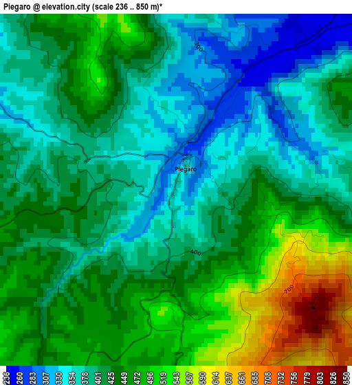
Below is the Elevation map of Piegaro, which displays elevation range with different colors. Scale of the first map is from 236 to 850 m (774 to 2789 ft) with average elevation of 426.4 meters (=1399 ft) [note 1]
These maps also provides idea of topography and contour of this city, they are displayed at different zoom levels. More info about maps, scale and edge coordinates you can find below images.
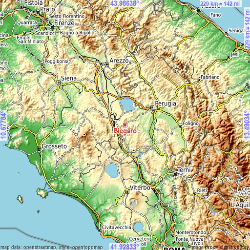
| \ | Map #1 | Topo.Map |
| Scale [m] | 236..850 m | × |
| Scale [ft] | 774..2789 ft | × |
| Average | 426.4 m = 1399 ft | × |
| Width | 7.15 km = 4.4 mi | 228.8 km = 142.2 mi |
| Height | 7.15 km = 4.4 mi | 228.8 km = 142.2 mi |
| ↑Max Latitude | 42.998109° | 43.98638° |
| Latitude at center | 42.96596° | 42.96596° |
| ↓Min Latitude | 42.933794° | 41.92833° |
| ← Min Longitude | 12.040145° | 10.67784° |
| Longitude center | 12.08409° | 12.08409° |
| →Max Longitude | 12.128035° | 13.49034° |
Nearby cities:
Cities around Piegaro sort by population:
• Chiusi Scalo elevation 266 m
11.1 km,  287°
287°
• Città della Pieve 484 m
6.3 km,  263°
263°
• Tavernelle 237 m
6.5 km,  50°
50°
• Chiusi 344 m
12.3 km,  295°
295°
• Fabro Scalo 247 m
10.5 km,  197°
197°
• Fontignano 277 m
10.9 km, 53°
• Fabro 262 m
11.8 km,  208°
208°
• Montegabbione 567 m
5.2 km,  172°
172°
• Monteleone d'Orvieto 493 m
5.5 km, 206°
• Paciano 364 m
6.5 km,  348°
348°
• Panicale 409 m
7.1 km,  10°
10°
• Parrano 456 m
11.3 km, 169°
Multilingual:
 En español:
Piegaro elevación 353 m.
 En France:
Piegaro élévation 353 m.


Sources and notes:
- [note 1] Map square and city borders are not equal. Map elevation data is calculated only from area inside that square.
- [src 1] Elevation data from geonames database provided with same terms of usage.
- [src 2] The elevation map of Piegaro is generated using elevation data from NASA's 3 arcsec (90m) resolution SRTM data.
- [src 3] Base (background) map © OpenStreetMap contributors tiles are generated by Geofabrik and OpenTopoMap.
Copyright & License:
This Piegaro Elevation Map is licensed under CC BY-SA. You may reuse any part from this page, if you give a proper credit by linking to this URL:
 More info on terms of use page.