Allerona elevation
Allerona (Umbria, Provincia di Terni), Italy elevation is 449 meters and Allerona elevation in feet is 1473 ft above sea level [src 1]. Allerona is a seat of a third-order administrative division (feature code) with elevation that is 127 meters (417 ft) bigger than average city elevation in Italy.
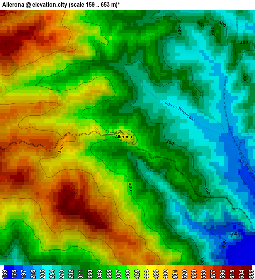
Below is the Elevation map of Allerona, which displays elevation range with different colors. Scale of the first map is from 159 to 653 m (522 to 2142 ft) with average elevation of 376.7 meters (=1236 ft) [note 1]
These maps also provides idea of topography and contour of this city, they are displayed at different zoom levels. More info about maps, scale and edge coordinates you can find below images.
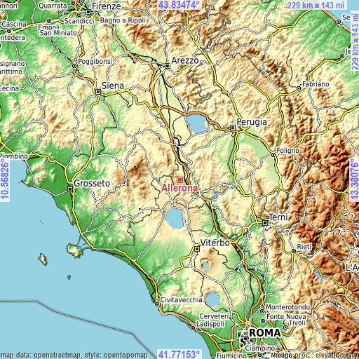
| \ | Map #1 | Topo.Map |
| Scale [m] | 159..653 m | × |
| Scale [ft] | 522..2142 ft | × |
| Average | 376.7 m = 1236 ft | × |
| Width | 7.17 km = 4.5 mi | 229.4 km = 142.5 mi |
| Height | 7.17 km = 4.5 mi | 229.4 km = 142.5 mi |
| ↑Max Latitude | 42.843969° | 43.83474° |
| Latitude at center | 42.81174° | 42.81174° |
| ↓Min Latitude | 42.779494° | 41.77153° |
| ← Min Longitude | 11.930565° | 10.56826° |
| Longitude center | 11.97451° | 11.97451° |
| →Max Longitude | 12.018455° | 13.38076° |
Nearby cities:
Cities around Allerona sort by population:
• Acquapendente elevation 388 m
11.6 km,  228°
228°
• Sferracavallo 150 m
13.7 km,  133°
133°
• Castel Giorgio 551 m
11.7 km,  178°
178°
• Fabro Scalo 247 m
9.2 km,  39°
39°
• Stazione di Allerona 189 m
5.9 km,  119°
119°
• Castel Viscardo 494 m
6.8 km,  161°
161°
• Fabro 262 m
7.6 km,  26°
26°
• Ficulle 454 m
7.9 km,  73°
73°
• Monteleone d'Orvieto 493 m
13.8 km, 27°
• San Casciano dei Bagni 565 m
10.3 km,  309°
309°
• Proceno 401 m
13.3 km,  243°
243°
• Parrano 456 m
12.6 km,  61°
61°
Multilingual:
 En español:
Allerona elevación 449 m.
 En France:
Allerona élévation 449 m.
 Auf Deutsch:
Allerona höhe über dem Meeresspiegel ist 449 m.

Sources and notes:
- [note 1] Map square and city borders are not equal. Map elevation data is calculated only from area inside that square.
- [src 1] Elevation data from geonames database provided with same terms of usage.
- [src 2] The elevation map of Allerona is generated using elevation data from NASA's 3 arcsec (90m) resolution SRTM data.
- [src 3] Base (background) map © OpenStreetMap contributors tiles are generated by Geofabrik and OpenTopoMap.
Copyright & License:
This Allerona Elevation Map is licensed under CC BY-SA. You may reuse any part from this page, if you give a proper credit by linking to this URL:
 More info on terms of use page.