Proceno elevation
Proceno (Latium, Provincia di Viterbo), Italy elevation is 401 meters and Proceno elevation in feet is 1316 ft above sea level [src 1]. Proceno is a seat of a third-order administrative division (feature code) with elevation that is 79 meters (259 ft) bigger than average city elevation in Italy.
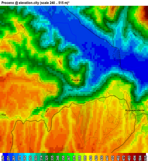
Below is the Elevation map of Proceno, which displays elevation range with different colors. Scale of the first map is from 240 to 515 m (787 to 1690 ft) with average elevation of 365.4 meters (=1199 ft) [note 1]
These maps also provides idea of topography and contour of this city, they are displayed at different zoom levels. More info about maps, scale and edge coordinates you can find below images.
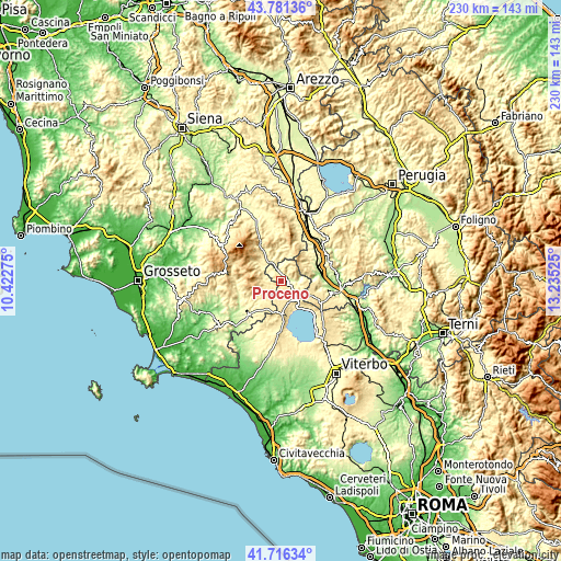
| \ | Map #1 | Topo.Map |
| Scale [m] | 240..515 m | × |
| Scale [ft] | 787..1690 ft | × |
| Average | 365.4 m = 1199 ft | × |
| Width | 7.18 km = 4.5 mi | 229.6 km = 142.7 mi |
| Height | 7.18 km = 4.5 mi | 229.6 km = 142.7 mi |
| ↑Max Latitude | 42.789708° | 43.78136° |
| Latitude at center | 42.75745° | 42.75745° |
| ↓Min Latitude | 42.725175° | 41.71634° |
| ← Min Longitude | 11.785055° | 10.42275° |
| Longitude center | 11.829° | 11.829° |
| →Max Longitude | 11.872945° | 13.23525° |
Nearby cities:
Cities around Proceno sort by population:
• Acquapendente elevation 388 m
3.6 km,  117°
117°
• Grotte di Castro 478 m
9.7 km,  160°
160°
• San Lorenzo Nuovo 496 m
10.2 km,  141°
141°
• Castel Giorgio 551 m
13.3 km,  114°
114°
• Gradoli 461 m
12.7 km,  170°
170°
• Castel Viscardo 494 m
14 km,  91°
91°
• Castell'Azzara 801 m
10.8 km,  279°
279°
• Onano 480 m
7.5 km,  188°
188°
• Latera 521 m
14.3 km,  179°
179°
• Sorano 409 m
12.3 km,  226°
226°
• San Casciano dei Bagni 565 m
13.1 km,  17°
17°
• Allerona 449 m
13.3 km,  63°
63°
Multilingual:
 En español:
Proceno elevación 401 m.
 En France:
Proceno élévation 401 m.


Sources and notes:
- [note 1] Map square and city borders are not equal. Map elevation data is calculated only from area inside that square.
- [src 1] Elevation data from geonames database provided with same terms of usage.
- [src 2] The elevation map of Proceno is generated using elevation data from NASA's 3 arcsec (90m) resolution SRTM data.
- [src 3] Base (background) map © OpenStreetMap contributors tiles are generated by Geofabrik and OpenTopoMap.
Copyright & License:
This Proceno Elevation Map is licensed under CC BY-SA. You may reuse any part from this page, if you give a proper credit by linking to this URL:
 More info on terms of use page.