Piazzolla elevation
Piazzolla (Campania, Napoli), Italy elevation is 54 meters and Piazzolla elevation in feet is 177 ft above sea level [src 1]. Piazzolla is a populated place (feature code) with elevation that is 268 meters (879 ft) smaller than average city elevation in Italy.
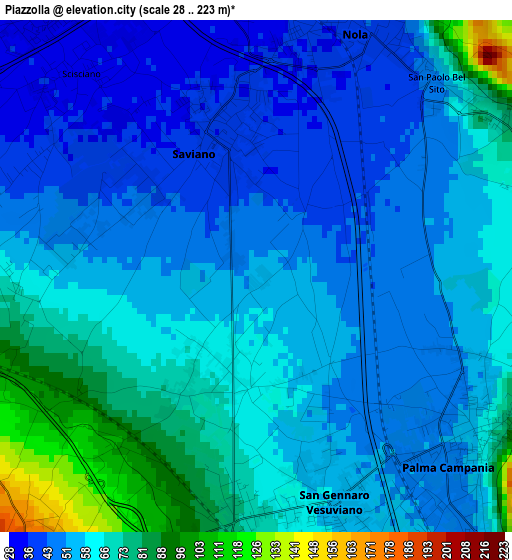
Below is the Elevation map of Piazzolla, which displays elevation range with different colors. Scale of the first map is from 28 to 223 m (92 to 732 ft) with average elevation of 58 meters (=190 ft) [note 1]
These maps also provides idea of topography and contour of this city, they are displayed at different zoom levels. More info about maps, scale and edge coordinates you can find below images.
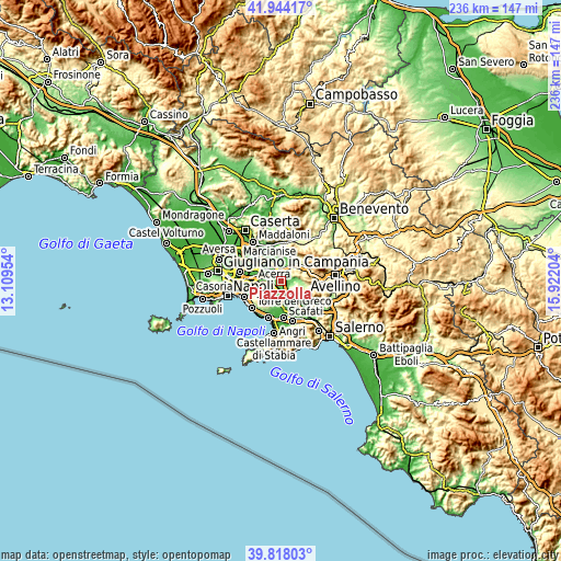
| \ | Map #1 | Topo.Map |
| Scale [m] | 28..223 m | × |
| Scale [ft] | 92..732 ft | × |
| Average | 58 m = 190 ft | × |
| Width | 7.39 km = 4.6 mi | 236.4 km = 146.9 mi |
| Height | 7.39 km = 4.6 mi | 236.4 km = 146.9 mi |
| ↑Max Latitude | 40.922853° | 41.94417° |
| Latitude at center | 40.88964° | 40.88964° |
| ↓Min Latitude | 40.85641° | 39.81803° |
| ← Min Longitude | 14.471845° | 13.10954° |
| Longitude center | 14.51579° | 14.51579° |
| →Max Longitude | 14.559735° | 15.92204° |
Nearby cities:
Cities around Piazzolla sort by population:
• Nola elevation 50 m
4.2 km,  14°
14°
• Ottaviano 184 m
5.2 km,  216°
216°
• Saviano 38 m
1.9 km,  332°
332°
• Palma Campania 53 m
4 km,  130°
130°
• San Gennaro Vesuviano 55 m
3.1 km,  167°
167°
• San Vitaliano 31 m
5.2 km,  318°
318°
• Piazzola 73 m
2.3 km,  214°
214°
• Scisciano 35 m
4 km,  298°
298°
• San Paolo Bel Sito 54 m
3.8 km,  46°
46°
• Carbonara di Nola 157 m
5.6 km,  107°
107°
• Liveri 82 m
4.5 km,  68°
68°
• Spartimento 59 m
3.7 km,  272°
272°
Multilingual:
 En español:
Piazzolla elevación 54 m.
 En France:
Piazzolla élévation 54 m.
 Auf Deutsch:
Piazzolla höhe über dem Meeresspiegel ist 54 m.

Sources and notes:
- [note 1] Map square and city borders are not equal. Map elevation data is calculated only from area inside that square.
- [src 1] Elevation data from geonames database provided with same terms of usage.
- [src 2] The elevation map of Piazzolla is generated using elevation data from NASA's 3 arcsec (90m) resolution SRTM data.
- [src 3] Base (background) map © OpenStreetMap contributors tiles are generated by Geofabrik and OpenTopoMap.
Copyright & License:
This Piazzolla Elevation Map is licensed under CC BY-SA. You may reuse any part from this page, if you give a proper credit by linking to this URL:
 More info on terms of use page.