Canavaccio elevation
Canavaccio (The Marches, Provincia di Pesaro e Urbino), Italy elevation is 168 meters and Canavaccio elevation in feet is 551 ft above sea level [src 1]. Canavaccio is a populated place (feature code) with elevation that is 154 meters (505 ft) smaller than average city elevation in Italy.
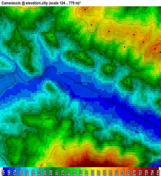
Below is the Elevation map of Canavaccio, which displays elevation range with different colors. Scale of the first map is from 124 to 779 m (407 to 2556 ft) with average elevation of 339.4 meters (=1114 ft) [note 1]
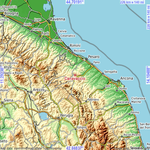
These maps also provides idea of topography and contour of this city, they are displayed at different zoom levels. More info about maps, scale and edge coordinates you can find below images.
| \ | Map #1 | Topo.Map |
| Scale [m] | 124..779 m | × |
| Scale [ft] | 407..2556 ft | × |
| Average | 339.4 m = 1114 ft | × |
| Width | 7.07 km = 4.4 mi | 226.1 km = 140.5 mi |
| Height | 7.07 km = 4.4 mi | 226.1 km = 140.5 mi |
| ↑Max Latitude | 43.725526° | 44.70191° |
| Latitude at center | 43.69376° | 43.69376° |
| ↓Min Latitude | 43.661977° | 42.66837° |
| ← Min Longitude | 12.654685° | 11.29238° |
| Longitude center | 12.69863° | 12.69863° |
| →Max Longitude | 12.742575° | 14.10488° |
Nearby cities:
Cities around Canavaccio sort by population:
• Fermignano elevation 188 m
3.6 km,  268°
268°
• Fossombrone 115 m
9.1 km,  92°
92°
• Urbino 447 m
6.2 km,  305°
305°
• Urbania 280 m
14.6 km,  258°
258°
• Acqualagna 205 m
7.7 km,  193°
193°
• Gallo 120 m
10.4 km,  6°
6°
• Sant'Ippolito 256 m
14.3 km,  96°
96°
• Isola del Piano 201 m
8.4 km,  54°
54°
• Montefelcino 256 m
11.8 km,  67°
67°
• Petriano 304 m
9.9 km,  15°
15°
• Colbordolo 299 m
14.2 km, 7°
• Montecalvo in Foglia 329 m
14.1 km,  337°
337°
Multilingual:
 En español:
Canavaccio elevación 168 m.
 En France:
Canavaccio élévation 168 m.
 Auf Deutsch:
Canavaccio höhe über dem Meeresspiegel ist 168 m.

Sources and notes:
- [note 1] Map square and city borders are not equal. Map elevation data is calculated only from area inside that square.
- [src 1] Elevation data from geonames database provided with same terms of usage.
- [src 2] The elevation map of Canavaccio is generated using elevation data from NASA's 3 arcsec (90m) resolution SRTM data.
- [src 3] Base (background) map © OpenStreetMap contributors tiles are generated by Geofabrik and OpenTopoMap.
Copyright & License:
This Canavaccio Elevation Map is licensed under CC BY-SA. You may reuse any part from this page, if you give a proper credit by linking to this URL:
 More info on terms of use page.