Gallo elevation
Gallo (The Marches, Provincia di Pesaro e Urbino), Italy elevation is 120 meters and Gallo elevation in feet is 394 ft above sea level [src 1]. Gallo is a populated place (feature code) with elevation that is 202 meters (663 ft) smaller than average city elevation in Italy.
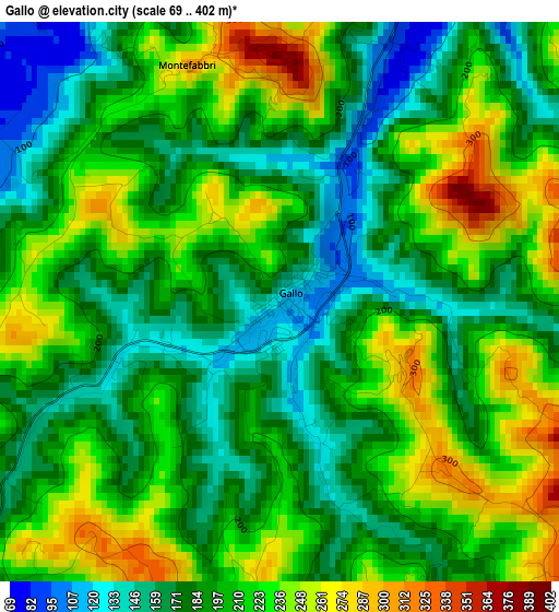
Below is the Elevation map of Gallo, which displays elevation range with different colors. Scale of the first map is from 69 to 402 m (226 to 1319 ft) with average elevation of 201.5 meters (=661 ft) [note 1]
These maps also provides idea of topography and contour of this city, they are displayed at different zoom levels. More info about maps, scale and edge coordinates you can find below images.
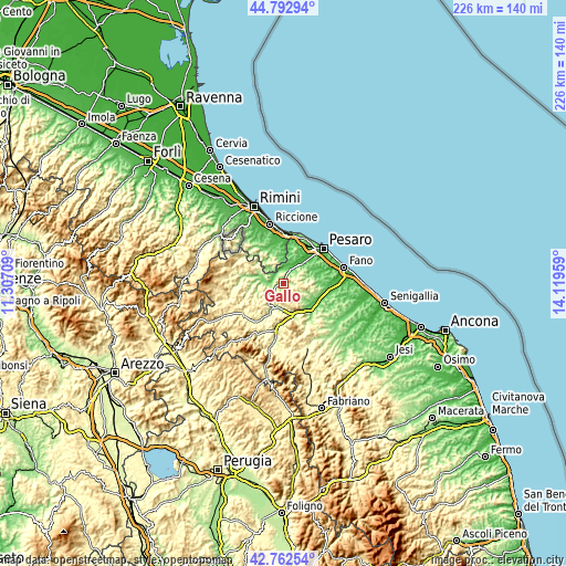
| \ | Map #1 | Topo.Map |
| Scale [m] | 69..402 m | × |
| Scale [ft] | 226..1319 ft | × |
| Average | 201.5 m = 661 ft | × |
| Width | 7.05 km = 4.4 mi | 225.8 km = 140.3 mi |
| Height | 7.06 km = 4.4 mi | 225.8 km = 140.3 mi |
| ↑Max Latitude | 43.818077° | 44.79294° |
| Latitude at center | 43.78636° | 43.78636° |
| ↓Min Latitude | 43.754626° | 42.76254° |
| ← Min Longitude | 12.669395° | 11.30709° |
| Longitude center | 12.71334° | 12.71334° |
| →Max Longitude | 12.757285° | 14.11959° |
Nearby cities:
Cities around Gallo sort by population:
• Cappone elevation 75 m
5.5 km,  26°
26°
• Bottega 59 m
7.2 km,  24°
24°
• Padiglione 60 m
7.3 km,  5°
5°
• Rio Salso-Case Bernardi 82 m
5.7 km,  340°
340°
• Borgo Massano 89 m
5.1 km,  327°
327°
• Monteciccardo 321 m
8.4 km,  59°
59°
• Sant'Angelo in Lizzola 288 m
8.3 km, 57°
• Isola del Piano 201 m
7.8 km,  133°
133°
• Petriano 304 m
1.7 km,  117°
117°
• Colbordolo 299 m
3.8 km, 9°
• Montecalvo in Foglia 329 m
7.1 km,  292°
292°
• Montegridolfo 269 m
8.2 km,  346°
346°
Multilingual:
 En español:
Gallo elevación 120 m.
 En France:
Gallo élévation 120 m.


Sources and notes:
- [note 1] Map square and city borders are not equal. Map elevation data is calculated only from area inside that square.
- [src 1] Elevation data from geonames database provided with same terms of usage.
- [src 2] The elevation map of Gallo is generated using elevation data from NASA's 3 arcsec (90m) resolution SRTM data.
- [src 3] Base (background) map © OpenStreetMap contributors tiles are generated by Geofabrik and OpenTopoMap.
Copyright & License:
This Gallo Elevation Map is licensed under CC BY-SA. You may reuse any part from this page, if you give a proper credit by linking to this URL:
 More info on terms of use page.