Sala al Barro elevation
Sala al Barro (Lombardy, Provincia di Lecco), Italy elevation is 253 meters and Sala al Barro elevation in feet is 830 ft above sea level [src 1]. Sala al Barro is a populated place (feature code) with elevation that is 69 meters (226 ft) smaller than average city elevation in Italy.
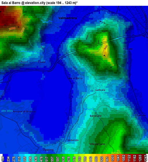
Below is the Elevation map of Sala al Barro, which displays elevation range with different colors. Scale of the first map is from 194 to 1243 m (636 to 4078 ft) with average elevation of 360.8 meters (=1184 ft) [note 1]
These maps also provides idea of topography and contour of this city, they are displayed at different zoom levels. More info about maps, scale and edge coordinates you can find below images.
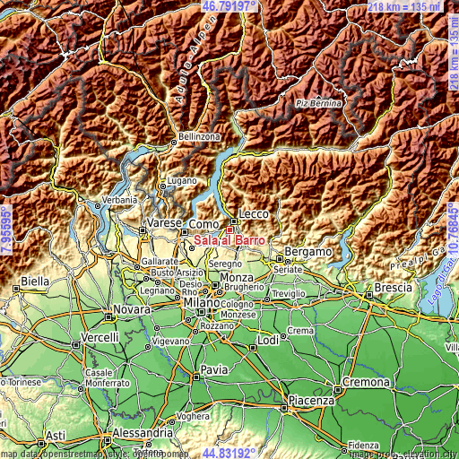
| \ | Map #1 | Topo.Map |
| Scale [m] | 194..1243 m | × |
| Scale [ft] | 636..4078 ft | × |
| Average | 360.8 m = 1184 ft | × |
| Width | 6.81 km = 4.2 mi | 217.9 km = 135.4 mi |
| Height | 6.81 km = 4.2 mi | 217.9 km = 135.4 mi |
| ↑Max Latitude | 45.851187° | 46.79197° |
| Latitude at center | 45.82057° | 45.82057° |
| ↓Min Latitude | 45.789936° | 44.83192° |
| ← Min Longitude | 9.318255° | 7.95595° |
| Longitude center | 9.3622° | 9.3622° |
| →Max Longitude | 9.406145° | 10.76845° |
Nearby cities:
Cities around Sala al Barro sort by population:
• Lecco elevation 223 m
4.8 km,  34°
34°
• Valmadrera-Caserta 231 m
2.9 km,  353°
353°
• Oggiono 276 m
3.4 km,  198°
198°
• Galbiate 362 m
1.4 km,  109°
109°
• Malgrate 230 m
3.3 km,  19°
19°
• Civate 275 m
1.7 km,  299°
299°
• Garlate 204 m
3.1 km, 108°
• Annone di Brianza 272 m
3.2 km,  229°
229°
• Pescate 205 m
2.8 km,  59°
59°
• Suello 263 m
3.9 km,  263°
263°
• Vergano-Villa 526 m
3.1 km,  161°
161°
• Ello 405 m
3.9 km,  176°
176°
Multilingual:
 En español:
Sala al Barro elevación 253 m.
 En France:
Sala al Barro élévation 253 m.
 Auf Deutsch:
Sala al Barro höhe über dem Meeresspiegel ist 253 m.

Sources and notes:
- [note 1] Map square and city borders are not equal. Map elevation data is calculated only from area inside that square.
- [src 1] Elevation data from geonames database provided with same terms of usage.
- [src 2] The elevation map of Sala al Barro is generated using elevation data from NASA's 3 arcsec (90m) resolution SRTM data.
- [src 3] Base (background) map © OpenStreetMap contributors tiles are generated by Geofabrik and OpenTopoMap.
Copyright & License:
This Sala al Barro Elevation Map is licensed under CC BY-SA. You may reuse any part from this page, if you give a proper credit by linking to this URL:
 More info on terms of use page.