Pescate elevation
Pescate (Lombardy, Provincia di Lecco), Italy elevation is 205 meters and Pescate elevation in feet is 673 ft above sea level [src 1]. Pescate is a seat of a third-order administrative division (feature code) with elevation that is 117 meters (384 ft) smaller than average city elevation in Italy.
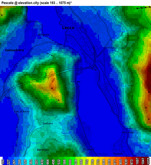
Below is the Elevation map of Pescate, which displays elevation range with different colors. Scale of the first map is from 193 to 1075 m (633 to 3527 ft) with average elevation of 339.5 meters (=1114 ft) [note 1]
These maps also provides idea of topography and contour of this city, they are displayed at different zoom levels. More info about maps, scale and edge coordinates you can find below images.
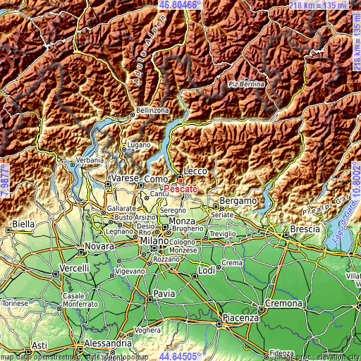
| \ | Map #1 | Topo.Map |
| Scale [m] | 193..1075 m | × |
| Scale [ft] | 633..3527 ft | × |
| Average | 339.5 m = 1114 ft | × |
| Width | 6.81 km = 4.2 mi | 217.9 km = 135.4 mi |
| Height | 6.81 km = 4.2 mi | 217.9 km = 135.4 mi |
| ↑Max Latitude | 45.86409° | 46.80466° |
| Latitude at center | 45.83348° | 45.83348° |
| ↓Min Latitude | 45.802853° | 44.84505° |
| ← Min Longitude | 9.350005° | 7.9877° |
| Longitude center | 9.39395° | 9.39395° |
| →Max Longitude | 9.437895° | 10.8002° |
Nearby cities:
Cities around Pescate sort by population:
• Lecco elevation 223 m
2.5 km,  5°
5°
• Calolziocorte 225 m
5.4 km,  141°
141°
• Valmadrera-Caserta 231 m
3.1 km,  297°
297°
• Olginate 202 m
5.1 km,  157°
157°
• Galbiate 362 m
2.2 km,  211°
211°
• Malgrate 230 m
2.2 km,  321°
321°
• Civate 275 m
4 km,  261°
261°
• Vercurago 222 m
3.5 km, 140°
• Garlate 204 m
2.4 km,  169°
169°
• Sala al Barro 253 m
2.8 km,  239°
239°
• Vergano-Villa 526 m
4.6 km,  198°
198°
• Erve 575 m
4.8 km,  106°
106°
Multilingual:
 En español:
Pescate elevación 205 m.
 En France:
Pescate élévation 205 m.


Sources and notes:
- [note 1] Map square and city borders are not equal. Map elevation data is calculated only from area inside that square.
- [src 1] Elevation data from geonames database provided with same terms of usage.
- [src 2] The elevation map of Pescate is generated using elevation data from NASA's 3 arcsec (90m) resolution SRTM data.
- [src 3] Base (background) map © OpenStreetMap contributors tiles are generated by Geofabrik and OpenTopoMap.
Copyright & License:
This Pescate Elevation Map is licensed under CC BY-SA. You may reuse any part from this page, if you give a proper credit by linking to this URL:
 More info on terms of use page.