Oggiono elevation
Oggiono (Lombardy, Provincia di Lecco), Italy elevation is 276 meters and Oggiono elevation in feet is 906 ft above sea level [src 1]. Oggiono is a seat of a third-order administrative division (feature code) with elevation that is 46 meters (151 ft) smaller than average city elevation in Italy.
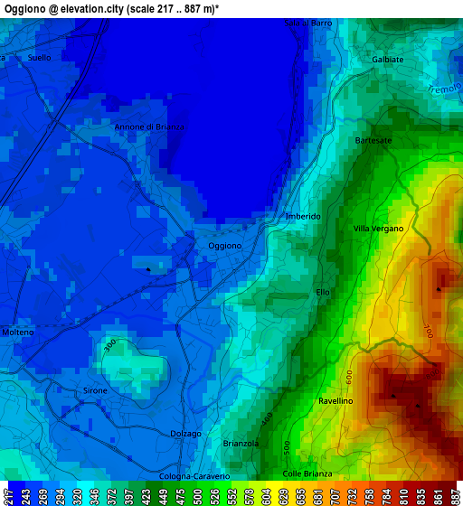
Below is the Elevation map of Oggiono, which displays elevation range with different colors. Scale of the first map is from 217 to 887 m (712 to 2910 ft) with average elevation of 366.9 meters (=1204 ft) [note 1]
These maps also provides idea of topography and contour of this city, they are displayed at different zoom levels. More info about maps, scale and edge coordinates you can find below images.
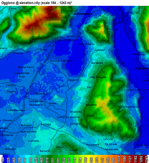
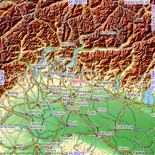
| \ | Map #1 | Map #2 | Topo.Map |
| Scale [m] | 217..887 m | 184..1243 m | × |
| Scale [ft] | 712..2910 ft | 604..4078 ft | × |
| Average | 366.9 m = 1204 ft | 385.1 m = 1263 ft | × |
| Width | 6.81 km = 4.2 mi | 13.63 km = 8.5 mi | 218.1 km = 135.5 mi |
| Height | 6.81 km = 4.2 mi | 13.63 km = 8.5 mi | 218 km = 135.5 mi |
| ↑Max Latitude | 45.821963° | 45.85258° | 46.76325° |
| Latitude at center | 45.79133° | 45.79133° | 45.79133° |
| ↓Min Latitude | 45.76068° | 45.730012° | 44.80216° |
| ← Min Longitude | 9.304205° | 9.260259° | 7.9419° |
| Longitude center | 9.34815° | 9.34815° | 9.34815° |
| →Max Longitude | 9.392095° | 9.436041° | 10.7544° |
Nearby cities:
Cities around Oggiono sort by population:
• Galbiate elevation 362 m
3.7 km,  40°
40°
• Molteno 271 m
3.7 km,  246°
246°
• Dolzago 285 m
2.8 km,  194°
194°
• Annone di Brianza 272 m
1.8 km,  312°
312°
• Castello di Brianza 307 m
3.6 km,  183°
183°
• Sirone 274 m
2.9 km,  224°
224°
• Sala al Barro 253 m
3.4 km,  18°
18°
• Cologna-Caraverio 306 m
3.9 km, 182°
• Colle Brianza 561 m
3.5 km,  158°
158°
• Vergano-Villa 526 m
2.1 km,  81°
81°
• Nava 555 m
3.4 km, 160°
• Ello 405 m
1.5 km,  115°
115°
Multilingual:
 En español:
Oggiono elevación 276 m.
 En France:
Oggiono élévation 276 m.


Sources and notes:
- [note 1] Map square and city borders are not equal. Map elevation data is calculated only from area inside that square.
- [src 1] Elevation data from geonames database provided with same terms of usage.
- [src 2] The elevation map of Oggiono is generated using elevation data from NASA's 3 arcsec (90m) resolution SRTM data.
- [src 3] Base (background) map © OpenStreetMap contributors tiles are generated by Geofabrik and OpenTopoMap.
Copyright & License:
This Oggiono Elevation Map is licensed under CC BY-SA. You may reuse any part from this page, if you give a proper credit by linking to this URL:
 More info on terms of use page.