Nava elevation
Nava (Lombardy, Provincia di Lecco), Italy elevation is 555 meters and Nava elevation in feet is 1821 ft above sea level [src 1]. Nava is a seat of a third-order administrative division (feature code) with elevation that is 233 meters (764 ft) bigger than average city elevation in Italy.
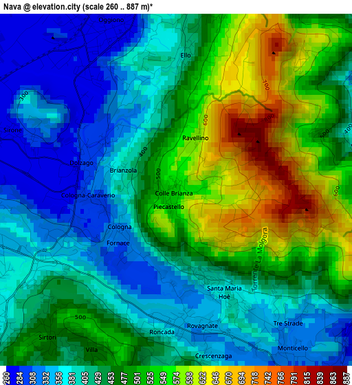
Below is the Elevation map of Nava, which displays elevation range with different colors. Scale of the first map is from 260 to 887 m (853 to 2910 ft) with average elevation of 452.3 meters (=1484 ft) [note 1]
These maps also provides idea of topography and contour of this city, they are displayed at different zoom levels. More info about maps, scale and edge coordinates you can find below images.
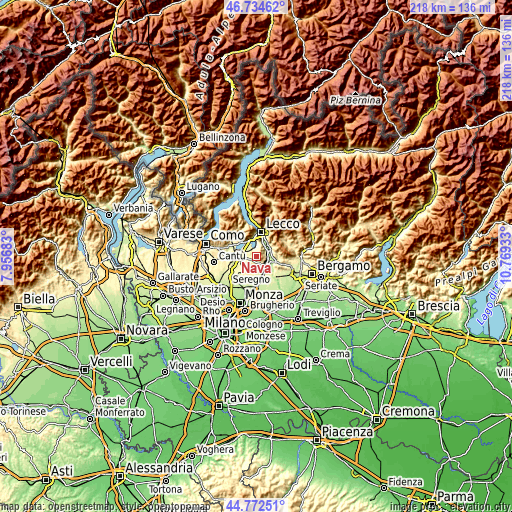
| \ | Map #1 | Topo.Map |
| Scale [m] | 260..887 m | × |
| Scale [ft] | 853..2910 ft | × |
| Average | 452.3 m = 1484 ft | × |
| Width | 6.82 km = 4.2 mi | 218.2 km = 135.6 mi |
| Height | 6.82 km = 4.2 mi | 218.2 km = 135.6 mi |
| ↑Max Latitude | 45.792839° | 46.73462° |
| Latitude at center | 45.76219° | 45.76219° |
| ↓Min Latitude | 45.731524° | 44.77251° |
| ← Min Longitude | 9.319135° | 7.95683° |
| Longitude center | 9.36308° | 9.36308° |
| →Max Longitude | 9.407025° | 10.76933° |
Nearby cities:
Cities around Nava sort by population:
• Oggiono elevation 276 m
3.4 km,  340°
340°
• Dolzago 285 m
1.9 km,  286°
286°
• Castello di Brianza 307 m
1.4 km,  256°
256°
• Sirone 274 m
3.4 km, 290°
• Rovagnate 337 m
2.9 km,  167°
167°
• Sirtori 461 m
3.8 km,  221°
221°
• Santa Maria Hoè 380 m
2.2 km,  156°
156°
• Cologna-Caraverio 306 m
1.5 km,  243°
243°
• Colle Brianza 561 m
0.1 km,  77°
77°
• Perego 337 m
2.7 km,  180°
180°
• Vergano-Villa 526 m
3.7 km,  14°
14°
• Ello 405 m
2.6 km,  3°
3°
Multilingual:
 En español:
Nava elevación 555 m.
 En France:
Nava élévation 555 m.


Sources and notes:
- [note 1] Map square and city borders are not equal. Map elevation data is calculated only from area inside that square.
- [src 1] Elevation data from geonames database provided with same terms of usage.
- [src 2] The elevation map of Nava is generated using elevation data from NASA's 3 arcsec (90m) resolution SRTM data.
- [src 3] Base (background) map © OpenStreetMap contributors tiles are generated by Geofabrik and OpenTopoMap.
Copyright & License:
This Nava Elevation Map is licensed under CC BY-SA. You may reuse any part from this page, if you give a proper credit by linking to this URL:
 More info on terms of use page.