Barbisano elevation
Barbisano (Veneto, Provincia di Treviso), Italy elevation is 129 meters and Barbisano elevation in feet is 423 ft above sea level [src 1]. Barbisano is a populated place (feature code) with elevation that is 193 meters (633 ft) smaller than average city elevation in Italy.
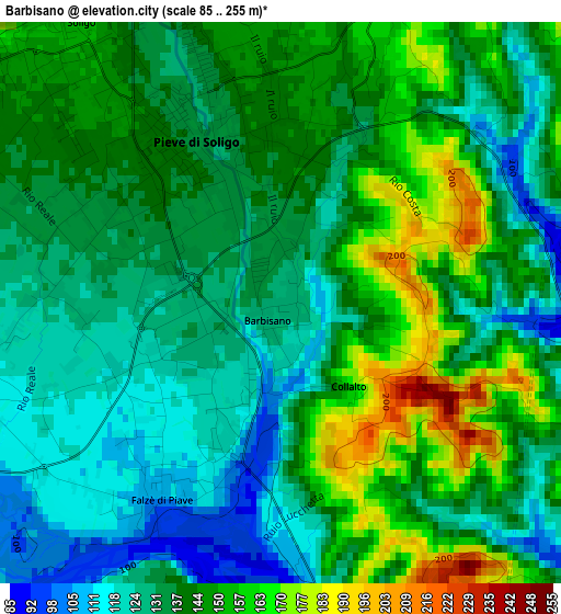
Below is the Elevation map of Barbisano, which displays elevation range with different colors. Scale of the first map is from 85 to 255 m (279 to 837 ft) with average elevation of 139.3 meters (=457 ft) [note 1]
These maps also provides idea of topography and contour of this city, they are displayed at different zoom levels. More info about maps, scale and edge coordinates you can find below images.
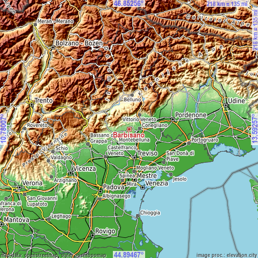
| \ | Map #1 | Topo.Map |
| Scale [m] | 85..255 m | × |
| Scale [ft] | 279..837 ft | × |
| Average | 139.3 m = 457 ft | × |
| Width | 6.8 km = 4.2 mi | 217.7 km = 135.3 mi |
| Height | 6.8 km = 4.2 mi | 217.7 km = 135.3 mi |
| ↑Max Latitude | 45.912823° | 46.85256° |
| Latitude at center | 45.88224° | 45.88224° |
| ↓Min Latitude | 45.85164° | 44.89467° |
| ← Min Longitude | 12.142375° | 10.78007° |
| Longitude center | 12.18632° | 12.18632° |
| →Max Longitude | 12.230265° | 13.59257° |
Nearby cities:
Cities around Barbisano sort by population:
• Pieve di Soligo elevation 136 m
2.1 km,  327°
327°
• Santa Lucia di Piave 48 m
8.6 km,  105°
105°
• Col San Martino 148 m
5.8 km,  290°
290°
• Farra di Soligo 161 m
5.4 km,  298°
298°
• San Pietro di Feletto 219 m
6.1 km,  54°
54°
• Nervesa della Battaglia 72 m
7.8 km,  173°
173°
• Sernaglia della Battaglia 115 m
4.3 km,  253°
253°
• Susegana 69 m
6.2 km,  117°
117°
• Falzè di Piave 118 m
1.7 km,  199°
199°
• Moriago della Battaglia 123 m
6.9 km, 254°
• Corbanese 133 m
8.2 km,  30°
30°
• Refrontolo 214 m
4.9 km,  20°
20°
Multilingual:
 En español:
Barbisano elevación 129 m.
 En France:
Barbisano élévation 129 m.
 Auf Deutsch:
Barbisano höhe über dem Meeresspiegel ist 129 m.

Sources and notes:
- [note 1] Map square and city borders are not equal. Map elevation data is calculated only from area inside that square.
- [src 1] Elevation data from geonames database provided with same terms of usage.
- [src 2] The elevation map of Barbisano is generated using elevation data from NASA's 3 arcsec (90m) resolution SRTM data.
- [src 3] Base (background) map © OpenStreetMap contributors tiles are generated by Geofabrik and OpenTopoMap.
Copyright & License:
This Barbisano Elevation Map is licensed under CC BY-SA. You may reuse any part from this page, if you give a proper credit by linking to this URL:
 More info on terms of use page.