Corbanese elevation
Corbanese (Veneto, Provincia di Treviso), Italy elevation is 133 meters and Corbanese elevation in feet is 436 ft above sea level [src 1]. Corbanese is a populated place (feature code) with elevation that is 189 meters (620 ft) smaller than average city elevation in Italy.
Below is the Elevation map of Corbanese, which displays elevation range with different colors. Scale of the first map is from 82 to 522 m (269 to 1713 ft) with average elevation of 211 meters (=692 ft) [note 1]
These maps also provides idea of topography and contour of this city, they are displayed at different zoom levels. More info about maps, scale and edge coordinates you can find below images.
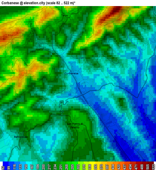
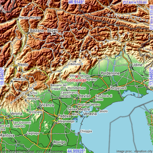
| \ | Map #1 | Topo.Map |
| Scale [m] | 82..522 m | × |
| Scale [ft] | 269..1713 ft | × |
| Average | 211 m = 692 ft | × |
| Width | 6.8 km = 4.2 mi | 217.4 km = 135.1 mi |
| Height | 6.8 km = 4.2 mi | 217.4 km = 135.1 mi |
| ↑Max Latitude | 45.976249° | 46.9149° |
| Latitude at center | 45.9457° | 45.9457° |
| ↓Min Latitude | 45.915135° | 44.95925° |
| ← Min Longitude | 12.196325° | 10.83402° |
| Longitude center | 12.24027° | 12.24027° |
| →Max Longitude | 12.284215° | 13.64652° |
Nearby cities:
Cities around Corbanese sort by population:
• Conegliano elevation 63 m
8 km,  143°
143°
• Vittorio Veneto 129 m
6 km,  50°
50°
• Pieve di Soligo 136 m
7.5 km,  225°
225°
• San Pietro di Feletto 219 m
3.6 km,  166°
166°
• Tarzo 275 m
3.6 km,  346°
346°
• Colle Umberto 129 m
7.9 km,  92°
92°
• Scomigo 91 m
6.2 km, 93°
• Cison di Valmarino 245 m
7.9 km,  287°
287°
• Revine 244 m
6.1 km,  11°
11°
• Carpesica 156 m
4 km,  77°
77°
• Refrontolo 214 m
3.5 km,  224°
224°
• Santa Maria 237 m
5.1 km, 351°
Multilingual:
 En español:
Corbanese elevación 133 m.
 En France:
Corbanese élévation 133 m.
 Auf Deutsch:
Corbanese höhe über dem Meeresspiegel ist 133 m.

Sources and notes:
- [note 1] Map square and city borders are not equal. Map elevation data is calculated only from area inside that square.
- [src 1] Elevation data from geonames database provided with same terms of usage.
- [src 2] The elevation map of Corbanese is generated using elevation data from NASA's 3 arcsec (90m) resolution SRTM data.
- [src 3] Base (background) map © OpenStreetMap contributors tiles are generated by Geofabrik and OpenTopoMap.
Copyright & License:
This Corbanese Elevation Map is licensed under CC BY-SA. You may reuse any part from this page, if you give a proper credit by linking to this URL:
 More info on terms of use page.