Tarzo elevation
Tarzo (Veneto, Provincia di Treviso), Italy elevation is 275 meters and Tarzo elevation in feet is 902 ft above sea level [src 1]. Tarzo is a seat of a third-order administrative division (feature code) with elevation that is 47 meters (154 ft) smaller than average city elevation in Italy.
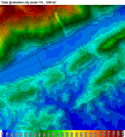
Below is the Elevation map of Tarzo, which displays elevation range with different colors. Scale of the first map is from 114 to 1249 m (374 to 4098 ft) with average elevation of 376.6 meters (=1236 ft) [note 1]
These maps also provides idea of topography and contour of this city, they are displayed at different zoom levels. More info about maps, scale and edge coordinates you can find below images.
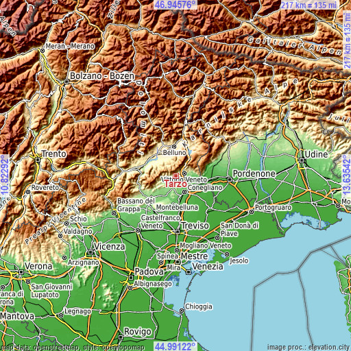
| \ | Map #1 | Topo.Map |
| Scale [m] | 114..1249 m | × |
| Scale [ft] | 374..4098 ft | × |
| Average | 376.6 m = 1236 ft | × |
| Width | 6.79 km = 4.2 mi | 217.3 km = 135 mi |
| Height | 6.79 km = 4.2 mi | 217.3 km = 135 mi |
| ↑Max Latitude | 46.007641° | 46.94576° |
| Latitude at center | 45.97711° | 45.97711° |
| ↓Min Latitude | 45.946562° | 44.99122° |
| ← Min Longitude | 12.185225° | 10.82292° |
| Longitude center | 12.22917° | 12.22917° |
| →Max Longitude | 12.273115° | 13.63542° |
Nearby cities:
Cities around Tarzo sort by population:
• Vittorio Veneto elevation 129 m
5.5 km,  86°
86°
• San Pietro di Feletto 219 m
7.2 km,  166°
166°
• Follina 195 m
8.8 km,  252°
252°
• Fregona 310 m
9.1 km,  67°
67°
• Colle Umberto 129 m
9.6 km,  113°
113°
• Corbanese 133 m
3.6 km, 166°
• Scomigo 91 m
8 km,  118°
118°
• Cison di Valmarino 245 m
6.8 km,  260°
260°
• Revine 244 m
3.2 km,  39°
39°
• Carpesica 156 m
5.5 km, 118°
• Refrontolo 214 m
6.2 km,  194°
194°
• Santa Maria 237 m
1.6 km,  2°
2°
Multilingual:
 En español:
Tarzo elevación 275 m.
 En France:
Tarzo élévation 275 m.


Sources and notes:
- [note 1] Map square and city borders are not equal. Map elevation data is calculated only from area inside that square.
- [src 1] Elevation data from geonames database provided with same terms of usage.
- [src 2] The elevation map of Tarzo is generated using elevation data from NASA's 3 arcsec (90m) resolution SRTM data.
- [src 3] Base (background) map © OpenStreetMap contributors tiles are generated by Geofabrik and OpenTopoMap.
Copyright & License:
This Tarzo Elevation Map is licensed under CC BY-SA. You may reuse any part from this page, if you give a proper credit by linking to this URL:
 More info on terms of use page.