Col San Martino elevation
Col San Martino (Veneto, Provincia di Treviso), Italy elevation is 148 meters and Col San Martino elevation in feet is 486 ft above sea level [src 1]. Col San Martino is a seat of a third-order administrative division (feature code) with elevation that is 174 meters (571 ft) smaller than average city elevation in Italy.
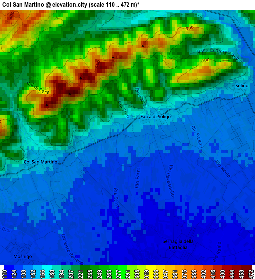
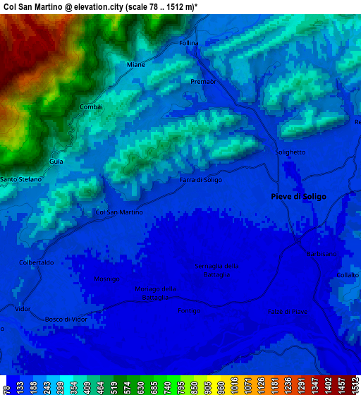
Below is the Elevation map of Col San Martino, which displays elevation range with different colors. Scale of the first map is from 110 to 472 m (361 to 1549 ft) with average elevation of 189.3 meters (=621 ft) [note 1]
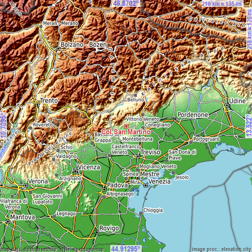
These maps also provides idea of topography and contour of this city, they are displayed at different zoom levels. More info about maps, scale and edge coordinates you can find below images.
| \ | Map #1 | Map #2 | Topo.Map |
| Scale [m] | 110..472 m | 78..1512 m | × |
| Scale [ft] | 361..1549 ft | 256..4961 ft | × |
| Average | 189.3 m = 621 ft | 267.6 m = 878 ft | × |
| Width | 6.8 km = 4.2 mi | 13.6 km = 8.5 mi | 217.6 km = 135.2 mi |
| Height | 6.8 km = 4.2 mi | 13.6 km = 8.5 mi | 217.6 km = 135.2 mi |
| ↑Max Latitude | 45.930774° | 45.96133° | 46.8702° |
| Latitude at center | 45.9002° | 45.9002° | 45.9002° |
| ↓Min Latitude | 45.86961° | 45.839002° | 44.91295° |
| ← Min Longitude | 12.071805° | 12.027859° | 10.7095° |
| Longitude center | 12.11575° | 12.11575° | 12.11575° |
| →Max Longitude | 12.159695° | 12.203641° | 13.522° |
Nearby cities:
Cities around Col San Martino sort by population:
• Pieve di Soligo elevation 136 m
4.3 km,  92°
92°
• Farra di Soligo 161 m
0.9 km,  49°
49°
• Sernaglia della Battaglia 115 m
3.5 km,  157°
157°
• Vidor 147 m
6.6 km,  235°
235°
• Falzè di Piave 118 m
6.1 km,  126°
126°
• Miane 256 m
5.1 km,  339°
339°
• Follina 195 m
5.9 km,  3°
3°
• Barbisano 129 m
5.8 km,  110°
110°
• Mosnigo 132 m
5 km,  214°
214°
• Moriago della Battaglia 123 m
4 km,  196°
196°
• Cison di Valmarino 245 m
7.7 km,  15°
15°
• Refrontolo 214 m
7.6 km,  70°
70°
Multilingual:
 En español:
Col San Martino elevación 148 m.
 En France:
Col San Martino élévation 148 m.
 Auf Deutsch:
Col San Martino höhe über dem Meeresspiegel ist 148 m.

Sources and notes:
- [note 1] Map square and city borders are not equal. Map elevation data is calculated only from area inside that square.
- [src 1] Elevation data from geonames database provided with same terms of usage.
- [src 2] The elevation map of Col San Martino is generated using elevation data from NASA's 3 arcsec (90m) resolution SRTM data.
- [src 3] Base (background) map © OpenStreetMap contributors tiles are generated by Geofabrik and OpenTopoMap.
Copyright & License:
This Col San Martino Elevation Map is licensed under CC BY-SA. You may reuse any part from this page, if you give a proper credit by linking to this URL:
 More info on terms of use page.