Lucino elevation
Lucino (Lombardy, Provincia di Como), Italy elevation is 312 meters and Lucino elevation in feet is 1024 ft above sea level [src 1]. Lucino is a seat of a third-order administrative division (feature code) with elevation that is 10 meters (33 ft) smaller than average city elevation in Italy.
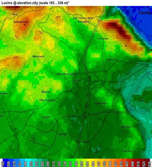
Below is the Elevation map of Lucino, which displays elevation range with different colors. Scale of the first map is from 193 to 536 m (633 to 1759 ft) with average elevation of 339.6 meters (=1114 ft) [note 1]
These maps also provides idea of topography and contour of this city, they are displayed at different zoom levels. More info about maps, scale and edge coordinates you can find below images.
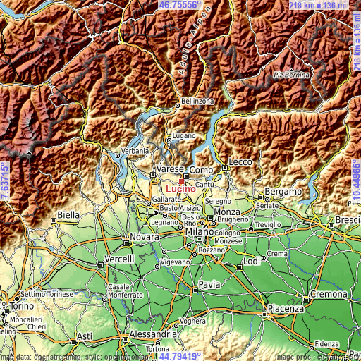
| \ | Map #1 | Topo.Map |
| Scale [m] | 193..536 m | × |
| Scale [ft] | 633..1759 ft | × |
| Average | 339.6 m = 1114 ft | × |
| Width | 6.82 km = 4.2 mi | 218.1 km = 135.5 mi |
| Height | 6.82 km = 4.2 mi | 218.1 km = 135.5 mi |
| ↑Max Latitude | 45.814138° | 46.75556° |
| Latitude at center | 45.7835° | 45.7835° |
| ↓Min Latitude | 45.752845° | 44.79419° |
| ← Min Longitude | 8.999455° | 7.63715° |
| Longitude center | 9.0434° | 9.0434° |
| →Max Longitude | 9.087345° | 10.44965° |
Nearby cities:
Cities around Lucino sort by population:
• Como elevation 213 m
4.1 km,  48°
48°
• Lurate Caccivio 332 m
3.9 km,  241°
241°
• Villa Guardia 361 m
1.8 km, 239°
• Casnate Con Bernate 333 m
3.8 km,  143°
143°
• Montano Lucino 313 m
0.1 km,  292°
292°
• San Fermo della Battaglia 398 m
2.8 km,  6°
6°
• Cavallasca 409 m
3 km,  344°
344°
• Grandate 303 m
2 km,  156°
156°
• Luisago 323 m
2.4 km,  195°
195°
• Cassina Rizzardi 323 m
3.8 km, 202°
• Montano 391 m
2 km,  305°
305°
• Gironico al Piano 373 m
3.7 km,  302°
302°
Multilingual:
 En español:
Lucino elevación 312 m.
 En France:
Lucino élévation 312 m.


Sources and notes:
- [note 1] Map square and city borders are not equal. Map elevation data is calculated only from area inside that square.
- [src 1] Elevation data from geonames database provided with same terms of usage.
- [src 2] The elevation map of Lucino is generated using elevation data from NASA's 3 arcsec (90m) resolution SRTM data.
- [src 3] Base (background) map © OpenStreetMap contributors tiles are generated by Geofabrik and OpenTopoMap.
Copyright & License:
This Lucino Elevation Map is licensed under CC BY-SA. You may reuse any part from this page, if you give a proper credit by linking to this URL:
 More info on terms of use page.