Grandate elevation
Grandate (Lombardy, Provincia di Como), Italy elevation is 303 meters and Grandate elevation in feet is 994 ft above sea level [src 1]. Grandate is a seat of a third-order administrative division (feature code) with elevation that is 19 meters (62 ft) smaller than average city elevation in Italy.
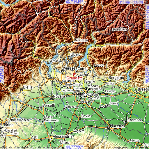
Below is the Elevation map of Grandate, which displays elevation range with different colors. Scale of the first map is from 230 to 451 m (755 to 1480 ft) with average elevation of 319.8 meters (=1049 ft) [note 1]
These maps also provides idea of topography and contour of this city, they are displayed at different zoom levels. More info about maps, scale and edge coordinates you can find below images.

| \ | Map #1 | Topo.Map |
| Scale [m] | 230..451 m | × |
| Scale [ft] | 755..1480 ft | × |
| Average | 319.8 m = 1049 ft | × |
| Width | 6.82 km = 4.2 mi | 218.1 km = 135.5 mi |
| Height | 6.82 km = 4.2 mi | 218.1 km = 135.5 mi |
| ↑Max Latitude | 45.797797° | 46.73949° |
| Latitude at center | 45.76715° | 45.76715° |
| ↓Min Latitude | 45.736486° | 44.77756° |
| ← Min Longitude | 9.009545° | 7.64724° |
| Longitude center | 9.05349° | 9.05349° |
| →Max Longitude | 9.097435° | 10.45974° |
Nearby cities:
Cities around Grandate sort by population:
• Lurate Caccivio elevation 332 m
4.2 km,  269°
269°
• Fino Mornasco 335 m
2.7 km,  185°
185°
• Villa Guardia 361 m
2.5 km,  290°
290°
• Casnate Con Bernate 333 m
1.9 km,  129°
129°
• Montano Lucino 313 m
2 km,  335°
335°
• Bulgarograsso 319 m
4.3 km,  238°
238°
• Cucciago 340 m
4.4 km,  135°
135°
• Luisago 323 m
1.5 km,  251°
251°
• Cassina Rizzardi 323 m
2.8 km,  233°
233°
• Lucino 312 m
2 km, 336°
• Montano 391 m
3.9 km,  321°
321°
• Navedano 277 m
3.5 km,  112°
112°
Multilingual:
 En español:
Grandate elevación 303 m.
 En France:
Grandate élévation 303 m.
 Auf Deutsch:
Grandate höhe über dem Meeresspiegel ist 303 m.

Sources and notes:
- [note 1] Map square and city borders are not equal. Map elevation data is calculated only from area inside that square.
- [src 1] Elevation data from geonames database provided with same terms of usage.
- [src 2] The elevation map of Grandate is generated using elevation data from NASA's 3 arcsec (90m) resolution SRTM data.
- [src 3] Base (background) map © OpenStreetMap contributors tiles are generated by Geofabrik and OpenTopoMap.
Copyright & License:
This Grandate Elevation Map is licensed under CC BY-SA. You may reuse any part from this page, if you give a proper credit by linking to this URL:
 More info on terms of use page.