Navedano elevation
Navedano (Lombardy, Provincia di Como), Italy elevation is 277 meters and Navedano elevation in feet is 909 ft above sea level [src 1]. Navedano is a populated place (feature code) with elevation that is 45 meters (148 ft) smaller than average city elevation in Italy.
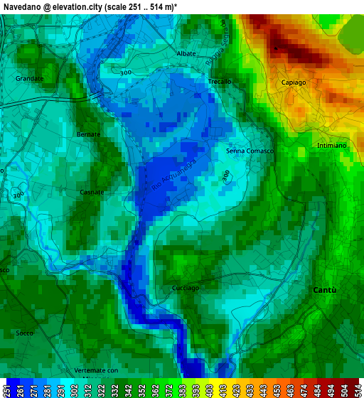
Below is the Elevation map of Navedano, which displays elevation range with different colors. Scale of the first map is from 251 to 514 m (823 to 1686 ft) with average elevation of 328.4 meters (=1077 ft) [note 1]
These maps also provides idea of topography and contour of this city, they are displayed at different zoom levels. More info about maps, scale and edge coordinates you can find below images.
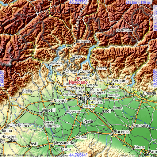
| \ | Map #1 | Topo.Map |
| Scale [m] | 251..514 m | × |
| Scale [ft] | 823..1686 ft | × |
| Average | 328.4 m = 1077 ft | × |
| Width | 6.82 km = 4.2 mi | 218.2 km = 135.6 mi |
| Height | 6.82 km = 4.2 mi | 218.2 km = 135.6 mi |
| ↑Max Latitude | 45.785893° | 46.72779° |
| Latitude at center | 45.75524° | 45.75524° |
| ↓Min Latitude | 45.72457° | 44.76544° |
| ← Min Longitude | 9.050755° | 7.68845° |
| Longitude center | 9.0947° | 9.0947° |
| →Max Longitude | 9.138645° | 10.50095° |
Nearby cities:
Cities around Navedano sort by population:
• Cantù elevation 362 m
3.2 km,  119°
119°
• Fino Mornasco 335 m
3.7 km,  248°
248°
• Lipomo 363 m
4.6 km,  25°
25°
• Capiago-Intimiano-Olmeda 416 m
3 km,  59°
59°
• Casnate Con Bernate 333 m
1.7 km,  273°
273°
• Vertemate Con Minoprio 325 m
3.7 km,  206°
206°
• Cucciago 340 m
1.8 km,  184°
184°
• Grandate 303 m
3.5 km,  292°
292°
• Luisago 323 m
4.7 km,  280°
280°
• Senna Comasco 302 m
1.5 km, 55°
• Montesolaro 316 m
4.2 km,  154°
154°
• Bulgorello 318 m
4.6 km,  221°
221°
Multilingual:
 En español:
Navedano elevación 277 m.
 En France:
Navedano élévation 277 m.
 Auf Deutsch:
Navedano höhe über dem Meeresspiegel ist 277 m.

Sources and notes:
- [note 1] Map square and city borders are not equal. Map elevation data is calculated only from area inside that square.
- [src 1] Elevation data from geonames database provided with same terms of usage.
- [src 2] The elevation map of Navedano is generated using elevation data from NASA's 3 arcsec (90m) resolution SRTM data.
- [src 3] Base (background) map © OpenStreetMap contributors tiles are generated by Geofabrik and OpenTopoMap.
Copyright & License:
This Navedano Elevation Map is licensed under CC BY-SA. You may reuse any part from this page, if you give a proper credit by linking to this URL:
 More info on terms of use page.