San Fermo della Battaglia elevation
San Fermo della Battaglia (Lombardy, Provincia di Como), Italy elevation is 398 meters and San Fermo della Battaglia elevation in feet is 1306 ft above sea level [src 1]. San Fermo della Battaglia is a seat of a third-order administrative division (feature code) with elevation that is 76 meters (249 ft) bigger than average city elevation in Italy.
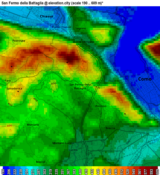
Below is the Elevation map of San Fermo della Battaglia, which displays elevation range with different colors. Scale of the first map is from 190 to 609 m (623 to 1998 ft) with average elevation of 343.3 meters (=1126 ft) [note 1]
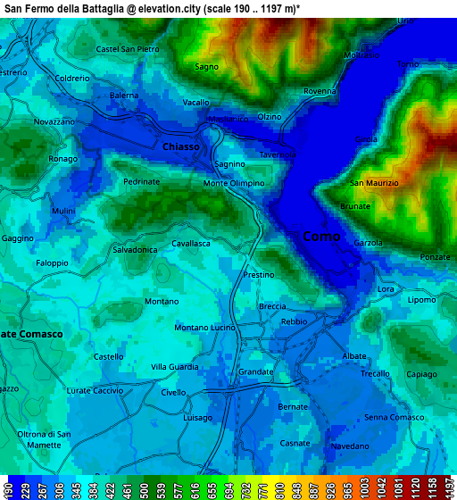
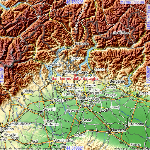
These maps also provides idea of topography and contour of this city, they are displayed at different zoom levels. More info about maps, scale and edge coordinates you can find below images.
| \ | Map #1 | Map #2 | Topo.Map |
| Scale [m] | 190..609 m | 190..1197 m | × |
| Scale [ft] | 623..1998 ft | 623..3927 ft | × |
| Average | 343.3 m = 1126 ft | 391.9 m = 1286 ft | × |
| Width | 6.81 km = 4.2 mi | 13.62 km = 8.5 mi | 218 km = 135.5 mi |
| Height | 6.81 km = 4.2 mi | 13.62 km = 8.5 mi | 218 km = 135.5 mi |
| ↑Max Latitude | 45.839304° | 45.869911° | 46.78029° |
| Latitude at center | 45.80868° | 45.80868° | 45.80868° |
| ↓Min Latitude | 45.778039° | 45.747382° | 44.81982° |
| ← Min Longitude | 9.003495° | 8.959549° | 7.64119° |
| Longitude center | 9.04744° | 9.04744° | 9.04744° |
| →Max Longitude | 9.091385° | 9.135331° | 10.45369° |
Nearby cities:
Cities around San Fermo della Battaglia sort by population:
• Como elevation 213 m
2.8 km,  91°
91°
• Villa Guardia 361 m
4.2 km,  206°
206°
• Cernobbio 286 m
4.3 km,  26°
26°
• Montano Lucino 313 m
2.8 km,  187°
187°
• Maslianico 246 m
3.8 km,  1°
1°
• Cavallasca 409 m
1.1 km,  275°
275°
• Grandate 303 m
4.6 km,  174°
174°
• Lucino 312 m
2.8 km, 186°
• Montano 391 m
2.5 km,  230°
230°
• Gironico al Piano 373 m
3.5 km,  256°
256°
• Brunate 711 m
4.2 km,  71°
71°
• Parè 415 m
3 km,  274°
274°
Multilingual:
 En español:
San Fermo della Battaglia elevación 398 m.
 En France:
San Fermo della Battaglia élévation 398 m.
 Auf Deutsch:
San Fermo della Battaglia höhe über dem Meeresspiegel ist 398 m.
 На русском:
Сан-Фермо-делла-Батталья высота над уровнем моря 398 м
Sources and notes:
- [note 1] Map square and city borders are not equal. Map elevation data is calculated only from area inside that square.
- [src 1] Elevation data from geonames database provided with same terms of usage.
- [src 2] The elevation map of San Fermo della Battaglia is generated using elevation data from NASA's 3 arcsec (90m) resolution SRTM data.
- [src 3] Base (background) map © OpenStreetMap contributors tiles are generated by Geofabrik and OpenTopoMap.
Copyright & License:
This San Fermo della Battaglia Elevation Map is licensed under CC BY-SA. You may reuse any part from this page, if you give a proper credit by linking to this URL:
 More info on terms of use page.