Marzanello elevation
Marzanello (Campania, Provincia di Caserta), Italy elevation is 149 meters and Marzanello elevation in feet is 489 ft above sea level [src 1]. Marzanello is a populated place (feature code) with elevation that is 173 meters (568 ft) smaller than average city elevation in Italy.
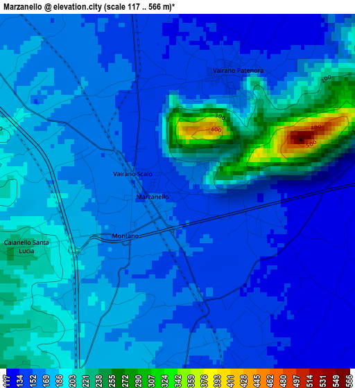
Below is the Elevation map of Marzanello, which displays elevation range with different colors. Scale of the first map is from 117 to 566 m (384 to 1857 ft) with average elevation of 172.9 meters (=567 ft) [note 1]
These maps also provides idea of topography and contour of this city, they are displayed at different zoom levels. More info about maps, scale and edge coordinates you can find below images.
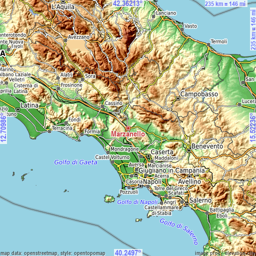
| \ | Map #1 | Topo.Map |
| Scale [m] | 117..566 m | × |
| Scale [ft] | 384..1857 ft | × |
| Average | 172.9 m = 567 ft | × |
| Width | 7.34 km = 4.6 mi | 234.9 km = 146 mi |
| Height | 7.34 km = 4.6 mi | 234.9 km = 146 mi |
| ↑Max Latitude | 41.347469° | 42.36213° |
| Latitude at center | 41.31447° | 41.31447° |
| ↓Min Latitude | 41.281454° | 40.2497° |
| ← Min Longitude | 14.072165° | 12.70986° |
| Longitude center | 14.11611° | 14.11611° |
| →Max Longitude | 14.160055° | 15.52236° |
Nearby cities:
Cities around Marzanello sort by population:
• Teano elevation 208 m
8.2 km,  210°
210°
• Pietramelara 141 m
7.7 km,  129°
129°
• Marzano Appio 296 m
5.9 km,  273°
273°
• Vairano-Patenora 140 m
2.8 km,  26°
26°
• Pietravairano 128 m
4.3 km,  73°
73°
• Caianello 202 m
2.8 km,  248°
248°
• Riardo 136 m
6.5 km,  153°
153°
• Grottola 315 m
6.3 km, 272°
• Presenzano 153 m
7.4 km,  343°
343°
• Santa Lucia 223 m
3.3 km, 249°
• Tora 312 m
8.2 km,  290°
290°
• Rocchetta 440 m
9.3 km,  158°
158°
Multilingual:
 En español:
Marzanello elevación 149 m.
 En France:
Marzanello élévation 149 m.
 Auf Deutsch:
Marzanello höhe über dem Meeresspiegel ist 149 m.

Sources and notes:
- [note 1] Map square and city borders are not equal. Map elevation data is calculated only from area inside that square.
- [src 1] Elevation data from geonames database provided with same terms of usage.
- [src 2] The elevation map of Marzanello is generated using elevation data from NASA's 3 arcsec (90m) resolution SRTM data.
- [src 3] Base (background) map © OpenStreetMap contributors tiles are generated by Geofabrik and OpenTopoMap.
Copyright & License:
This Marzanello Elevation Map is licensed under CC BY-SA. You may reuse any part from this page, if you give a proper credit by linking to this URL:
 More info on terms of use page.