Presenzano elevation
Presenzano (Campania, Provincia di Caserta), Italy elevation is 153 meters and Presenzano elevation in feet is 502 ft above sea level [src 1]. Presenzano is a seat of a third-order administrative division (feature code) with elevation that is 169 meters (554 ft) smaller than average city elevation in Italy.
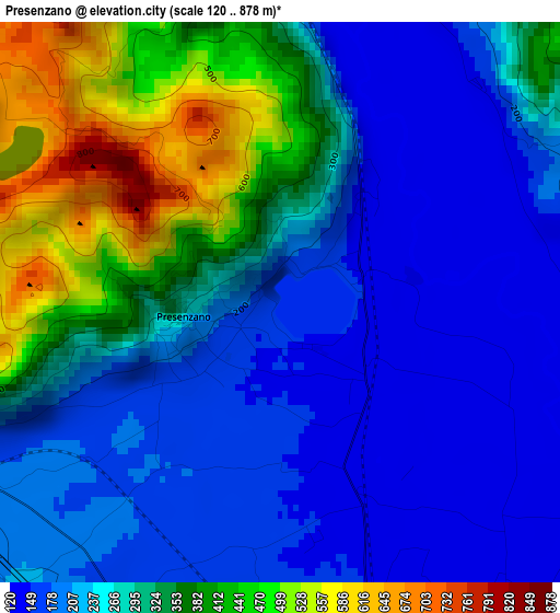
Below is the Elevation map of Presenzano, which displays elevation range with different colors. Scale of the first map is from 120 to 878 m (394 to 2881 ft) with average elevation of 275.7 meters (=905 ft) [note 1]
These maps also provides idea of topography and contour of this city, they are displayed at different zoom levels. More info about maps, scale and edge coordinates you can find below images.
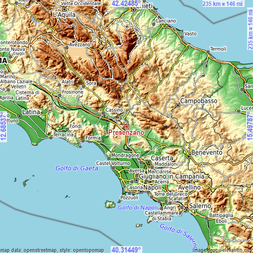
| \ | Map #1 | Topo.Map |
| Scale [m] | 120..878 m | × |
| Scale [ft] | 394..2881 ft | × |
| Average | 275.7 m = 905 ft | × |
| Width | 7.33 km = 4.6 mi | 234.7 km = 145.8 mi |
| Height | 7.33 km = 4.6 mi | 234.6 km = 145.8 mi |
| ↑Max Latitude | 41.411197° | 42.42485° |
| Latitude at center | 41.37823° | 41.37823° |
| ↓Min Latitude | 41.345247° | 40.31449° |
| ← Min Longitude | 14.047675° | 12.68537° |
| Longitude center | 14.09162° | 14.09162° |
| →Max Longitude | 14.135565° | 15.49787° |
Nearby cities:
Cities around Presenzano sort by population:
• Marzano Appio elevation 296 m
7.8 km,  210°
210°
• Marzanello 149 m
7.4 km,  163°
163°
• Vairano-Patenora 140 m
5.6 km,  144°
144°
• Pietravairano 128 m
8.6 km,  133°
133°
• Mignano Monte Lungo 126 m
9.4 km,  289°
289°
• Caianello 202 m
8.2 km,  183°
183°
• Grottola 315 m
8 km, 211°
• Ailano 229 m
9.6 km,  82°
82°
• Santa Lucia 223 m
8.3 km,  187°
187°
• Pratella 169 m
7.9 km,  67°
67°
• Sesto Campano 288 m
4.8 km,  346°
346°
• Tora 312 m
7.1 km,  232°
232°
Multilingual:
 En español:
Presenzano elevación 153 m.
 En France:
Presenzano élévation 153 m.
 Auf Deutsch:
Presenzano höhe über dem Meeresspiegel ist 153 m.

Sources and notes:
- [note 1] Map square and city borders are not equal. Map elevation data is calculated only from area inside that square.
- [src 1] Elevation data from geonames database provided with same terms of usage.
- [src 2] The elevation map of Presenzano is generated using elevation data from NASA's 3 arcsec (90m) resolution SRTM data.
- [src 3] Base (background) map © OpenStreetMap contributors tiles are generated by Geofabrik and OpenTopoMap.
Copyright & License:
This Presenzano Elevation Map is licensed under CC BY-SA. You may reuse any part from this page, if you give a proper credit by linking to this URL:
 More info on terms of use page.