Sesto Campano elevation
Sesto Campano (Molise, Provincia di Isernia), Italy elevation is 288 meters and Sesto Campano elevation in feet is 945 ft above sea level [src 1]. Sesto Campano is a seat of a third-order administrative division (feature code) with elevation that is 34 meters (112 ft) smaller than average city elevation in Italy.
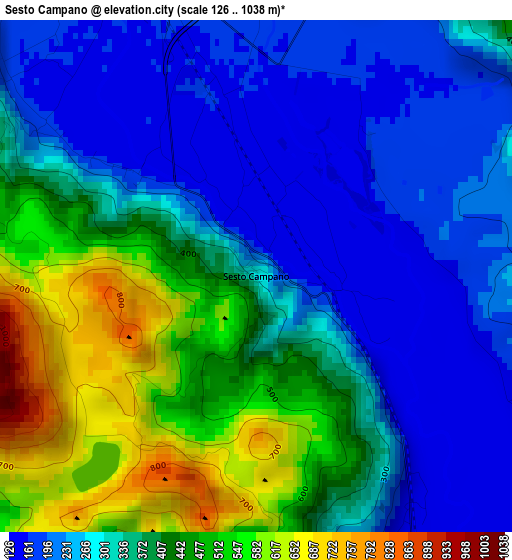
Below is the Elevation map of Sesto Campano, which displays elevation range with different colors. Scale of the first map is from 126 to 1038 m (413 to 3406 ft) with average elevation of 346.6 meters (=1137 ft) [note 1]
These maps also provides idea of topography and contour of this city, they are displayed at different zoom levels. More info about maps, scale and edge coordinates you can find below images.
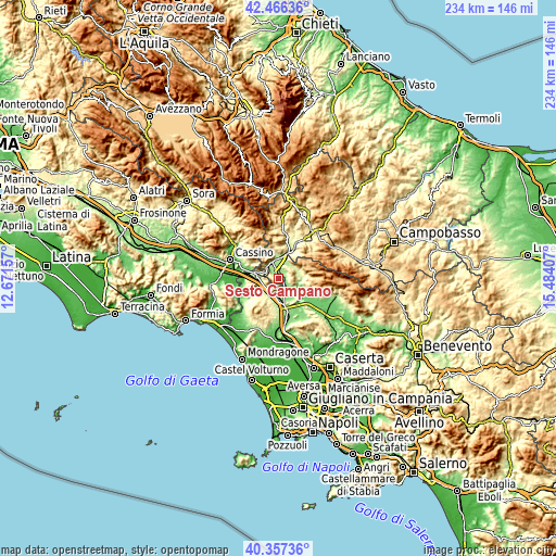
| \ | Map #1 | Topo.Map |
| Scale [m] | 126..1038 m | × |
| Scale [ft] | 413..3406 ft | × |
| Average | 346.6 m = 1137 ft | × |
| Width | 7.33 km = 4.6 mi | 234.5 km = 145.7 mi |
| Height | 7.33 km = 4.6 mi | 234.5 km = 145.7 mi |
| ↑Max Latitude | 41.453365° | 42.46636° |
| Latitude at center | 41.42042° | 41.42042° |
| ↓Min Latitude | 41.387458° | 40.35736° |
| ← Min Longitude | 14.033875° | 12.67157° |
| Longitude center | 14.07782° | 14.07782° |
| →Max Longitude | 14.121765° | 15.48407° |
Nearby cities:
Cities around Sesto Campano sort by population:
• Venafro elevation 178 m
7.4 km,  340°
340°
• Vairano-Patenora 140 m
10.3 km,  154°
154°
• Mignano Monte Lungo 126 m
7.9 km,  258°
258°
• Pozzilli 239 m
10.2 km,  352°
352°
• Capriati A Volturno 283 m
7.8 km,  47°
47°
• San Pietro Infine 130 m
10.2 km,  285°
285°
• Presenzano 153 m
4.8 km,  166°
166°
• Fontegreca 321 m
9.7 km,  65°
65°
• Pratella 169 m
8.6 km,  100°
100°
• Tora 312 m
10 km,  206°
206°
• Conca Casale 656 m
10.2 km,  324°
324°
• Ciorlano 319 m
7.5 km,  63°
63°
Multilingual:
 En español:
Sesto Campano elevación 288 m.
 En France:
Sesto Campano élévation 288 m.
 Auf Deutsch:
Sesto Campano höhe über dem Meeresspiegel ist 288 m.

Sources and notes:
- [note 1] Map square and city borders are not equal. Map elevation data is calculated only from area inside that square.
- [src 1] Elevation data from geonames database provided with same terms of usage.
- [src 2] The elevation map of Sesto Campano is generated using elevation data from NASA's 3 arcsec (90m) resolution SRTM data.
- [src 3] Base (background) map © OpenStreetMap contributors tiles are generated by Geofabrik and OpenTopoMap.
Copyright & License:
This Sesto Campano Elevation Map is licensed under CC BY-SA. You may reuse any part from this page, if you give a proper credit by linking to this URL:
 More info on terms of use page.